Kempston Maps
Please click on the relevant thumbnail to see a larger image.
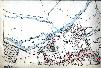
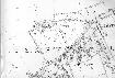
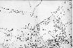
Kempston in 1804 [X1/25]
![Kempston in 1804 [X1-25]](/CommunityHistories/Kempston/KempstonImages/Kempston in 1804 [X1-25]_150x132.jpg)
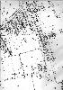
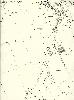
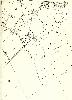
1st edition 25 inches to the mile Ordnance Survey maps of 1884
![Ordnance survey map of Bedford Road and High Street north to the river and as far east as Spring Road](/CommunityHistories/Kempston/KempstonImages/OS 140 Kempston 1st ed pt 1_101x68.jpg)
Bedford Road and High Street north to the river and as far east as Spring Road
![Ordnance survey map from St. John's Road to Spring Road](/CommunityHistories/Kempston/KempstonImages/OS 140 Kemspton 1st ed pt 2_101x68.jpg)
From Saint John's Road to Spring Road
![Ordnance survey map of New Town from Spring Road to the Barracks](/CommunityHistories/Kempston/KempstonImages/OS 140 Kempston 1st ed pt 3_101x71.jpg)
New Town from Spring Road to the Barracks
2nd edition Ordnance Survey 25 inches to the mile maps of 1901
![Ordnance survey map from Bedford Road and High Street North to river and east to Spring Road](/CommunityHistories/Kempston/KempstonImages/OS 140 Kemspton 2nd ed pt 1_100x61.jpg)
Bedford Road and High Street north to the river and as far east as Spring Road
![Ordnance survey map from St. John's Road to Spring Road](/CommunityHistories/Kempston/KempstonImages/OS 140 Kemspton 2nd ed pt 2_100x60.jpg)
From Saint John's Road to Spring Road
From Margetts Road to just east of the Barracks
![Ordnance survery map Kempston Grange and Bedford Road from Margetts Road to just east of the Barracks](/CommunityHistories/Kempston/KempstonImages/OS 140 Kemspton 2nd ed pt 4_105x71.jpg)
Kempston Grange and Bedford Road from Margetts Road to just east of the Barracks
Woburn Road from junction with Saint John's Street and Bunyan Road south
Around Kempston Hoo
3rd edition Ordnance Survey 25 inches to the mile maps of 1926
Bedford Road and High Street north to the river and as far east as Spring Road
![Ordnance survey ,ap From St. John's Road to Spring Road](/CommunityHistories/Kempston/KempstonImages/OS 140 Kemspton 3rd ed pt 1_106x70.jpg)
From Saint John's Road to Spring Road
![Ordnance survey map South of Bedford Road from Margetts Road to Spring Road](/CommunityHistories/Kempston/KempstonImages/OS 140 Kemspton 3rd ed pt 3_70x100.jpg)
South of Bedford Road from Margetts Road to Spring Road
![Ordnance survey map north of Bedford Road from Margetts Road to the Borough boundary](/CommunityHistories/Kempston/KempstonImages/OS 140 Kemspton 3rd ed pt 4_66x99.jpg)
North of Bedford Road from Margetts Road to the Borough boundary
![Ordnance survey map Woburn Road from junction with St. John's Street and Bunyan Road south](/CommunityHistories/Kempston/KempstonImages/OS 154 Kemspton 3rd ed pt 1_74x100.jpg)
Woburn Road from junction with Saint John's Street and Bunyan Road south
Around Kempston Hoo