Introduction
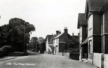
Kempston High Street looking west from the Half Moon about 1920 [ref: Z209/95/83]
Before Domesday
Finds of stone tools, mostly in the 19th century, have revealed that Kempston, not surprisingly given its location near the River Great Ouse, was inhabited in prehistory as far back in time as the Palaeolithic or Old Stone Age (before 10,000BC). A considerable number of finds have been made in the Hillgrounds area of the urban parish of Kempston containing material from a great swathe of Kempston's past from the Palaeolithic to the Anglo-Saxon period indicating that this was either an area or the area of ancient settlement, however no remains of buildings have been found. A Bronze Age barrow lay south of Hillgrounds and an Iron Age cemetery later formed around it.
There was a large cemetery at Up End which ran from the Roman occupation well into the Anglo-Saxon period. Some burials were clearly of individuals of high status as they included gold, ivory, amber and glass; a very fine glass beaker from the 5th or 6th century is now in the British Museum. The Saxon Shopping Centre at the corner of Bunyan Road and Bedford Road now lies on the site.
Name
The name Kempston was first recorded in 1060 as Kemestan and has had a bewildering number of variations over the years including: Coembestun (1350); Cæmbestune (1077); Camestone (1086-1200); Canbestuna (1124-1128); Kembeston (1176-1325); Kemeston (1189-1332); Kamistuna (1195); Camestun (1195); Chemiston (1199); Cemeston (1199); Cambesdon and Kimbeston (1201); Cambeston (1236); Kemston (1236-1349); Kembestun (1237-1253); Kemestun (1241); Kemyston (1242); Kempeston (1276-1306); Kemmeston (1276); Camston (1328); and Cameston (1332). The modern form of the name first appears in 1247; the name appears to mean homestead on the bend (the great bend taken by the River Great Ouse).
Parish
Kempston was an ancient parish in the Redbornstoke Hundred. In 1896 the civil parish was divided into two: Kempston Urban District, now simply called Kempston, and the civil parish of Kempston Rural. The urban district comprised, essentially Bell End and Up End, names which can only be traced back to the 17th or 18th century and New Town. Bell End was, essentially, that part of Kempston in the west of the modern parish based around Kempston High Street. It was, presumably, named after the Bell beerhouse which stood in Water Lane until the early 19th century. Up End lay to the south of the modern parish and was based around the modern Woburn Road, St.John's Street and Bunyan Road. New Town was in the east of the modern parish and comprised everything between Bunyan Road and the modern King Street and the Bedford boundary. Mill End, obviously that area around the mill was recorded in the Middle Ages but has not survived whereas Gravel End was invented in the 19th century to cover an area around Bunyan Road, although this name, too, has not survived the test of time.
The modern civil parish of Kempston is bounded by Bedford to the north-east, Elstow south-east, Kempston Rural south and west and Biddenham north-west. It consists of about 1,255 acres (500 hectares), the soil is clay with a limestone and gravel sub-soil. Nowhere in the parish does the height above sea level exceed 275 feet and at the north-east boundary, formed by the River Great Ouse the land lies as low as 93 feet.
Domesday
In 1086 Countess Judith held 10 hides in Kempston. She was a niece of William the Conqueror and wife of Earl Waltheof of Huntingdon and Northumbria, who had rebelled against William, been betrayed to him by Judith, and been executed in 1076. Judith herself lost all her lands at around the time of Domesday when she angered her uncle by refusing to marry earl Simon of Northampton. Judith held the manor herself rather than leasing it to a tenant. In 1086 it included 18 villagers, 12 smallholders and 8 slaves. It also included a mill (worth 5 shillings) and woodland for 200 pigs. In 1066 Kempston had been held by Earl Gyrth, brother of King Harold, who had died with him at Hastings. In addition two thegns had held another 2½ hides and 1½ virgates. The manor had been worth the very considerable sum of £30 in 1066, which had fallen to £22 when Judith acquired it and still further to £18 in 1086. Historians consider that the reason for this depreciation of land across Bedfordshire was the damage inflicted on it by William the Conqueror’s armies as the moved north to quell rebellion.
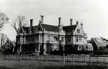
Kempston Hoo [ref: Z50/67/3]
Manors
Kempston Manor
Kempston Manor formed part of the Honour of Huntingdon and was held from the King for the rent of one red sparrow hawk. The last earl of Huntingdon in his line was John le Scot, who died in 1237. At his death his three sisters divided his estates between them, including Kempston Manor – which was divided into the manors of Daubeney, Brucebury and Hardwick.
Manor of Kempston Daubeney
This manor was created from the Manor of Kempston for John le Scot’s eldest sister Margaret, wife of Alan, Lord Galloway. It passed to her daughter Devorgilla, wife of John de Baliol and , on her death in 1290, passed to her son John, one of eight claimants to the throne of Scotland! John duly became King of Scotland in 1292 but forfeited his crown when rebelling against King Edward I of England in 1296. The Manor of Kempston Daubeney was thus seized by the English Crown and bestowed on Edward’s nephew John de Brittany, Earl of Richmond in 1306. The Earl granted reversion of the manor to William Glaykyn in 1331 and, on his death in 1333, to William Daubeney. The manor remained in the Daubeney family until 1483 when Giles Daubeney was implicated in the Duke of Buckingham’s revolt against Richard III and he fled to Brittany. His estates were confiscated and Richard awarded Daubeney Manor to Sir John Egremont. On Henry VII’s victory at Bosworth Field Daubeney was restored to his lands and was created a Baron in 1486. In 1502 he alienated Daubeney Manor to his friend, and fellow plotter against Richard III, Sir Reginald Bray.
The manor remained in the Bray family until alienated in 1569 to Thomas Snagge, Speaker of the House of Commons in 1588-1589. His son Thomas became High Sheriff and MP for Bedfordshire. In 1659 the Manor was alienated by Charles Snagge to Robert Yarway who, next year, conveyed it to Matthew Dennis. The Dennis family then held the manor until it was conveyed to Rev.Edmund Ryland Williamson in 1813 and remained in that family into the 20th century (all manorial incidents, courts and tenure of land being abolished under the Law of Property Act 1922.).
Manor of Kempston Brucebury, later Draytons
This manor was created for John le Scot’s second sister, Isabel, wife of Robert Bruce. The manor remained in the family until 1306 when Isabel’s great-great-grandson Robert Bruce became King of Scotland and his English estates were seized by King Edward I. Edward bestowed Kempston Brucebury on Roger de Wellesworth for life in 1307 and, on his death in 1316, it was given for life to James de Audele, who died in the early 1330s when Edward III granted Brucebury to William Trussel for life but in 1338 was empowered to hold the manor for his life and those of his heirs. His daughter, wife of Sir Fulk Pembridge, granted the manor to Sir Hugh de Segrave, former Chancellor of England, in 1383. On Segrave’s death in 1387 the manor was conveyed by his trustees to Nicholas Drayton. His Granddaughters inherited the manor in 1417 and it was divided between them. One half went to Joan, who married Drew Barantyn and it remained I that family until alienated to John Vavasour in the late 15th century. Vavasour conveyed the half share in the manor to John Fisher in 1500 and it eventually passed to his great-granddaughter who married into the St.John family. By 1593 the half share in the manor had been purchased from the St.John's by Thomas Snagge and it was held in the same way from then on as the Manor of Kempston Daubeney. The other half of the Manor of Kempston Brucebury went to Elizabeth Drayton, Joan's sister in 1417 and became known as the Manor of Kempston Hardwick.
Manor of Kempston Hastingsbury, later Greys
This manor was created for John le Scot's third sister Ada, who married Henry Hastings and it remained in the Hastings family until the death of John Hastings, childless, in 1389, when it passed to his cousin Reginald, Lord de Grey of Ruthyn, who also held the Manor of Wrest in Silsoe. The de Greys held both manors until the middle of the 15th century when they conveyed their ken manor to a junior branch of the family. This portion of the Grey family held the manor until 1536 when it was appropriated by the Crown following a dispute between Reginald Grey (d.1534) and his wife Elizabeth and their tenants. The Crown recognised a claim by the brothers Thomas and Francis FitzWilliam, who had been granted the reversion of the manor by Elizabeth Grey in 1534. Francis alienated his half to Roger Chalenor in 1545, his son alienating it to Thomas Leigh in 1550 who conveyed it in 1561 to William Bendlowes. Bendlowes joined with Thomas FitzWilliam to convey the whole manor in 1573 to Humphrey FitzWilliam and it remained in the family until sold in 1619 to Sir John Wild. Before 1624 the Wilds alienated the manor to William Cater and remained in this family until 1736 when inherited by Robert Kendall, who then changed his name to Cater; the manor was divided by the three daughters of John Kendall Cater around 1778 but they combined in 1801 to sell it to William Long. Around 1850 the manor was purchased by Talbot Barnard and about 1885 sold to Walter Harter who remained Lord of the Manor into the 20th century
Manor of Stafford
This manor appears in Kempston in the 15th century, when in the tenure of Thomas Stafford. The Stafford family alienated it in 1563 to Thomas Ashfield. By 1685 it was in the possession of Guy Hillersdon, suggesting it may have been near the boundary with Elstow. This manor is last mentioned in 1720 when owned by Michael Hillersdon.
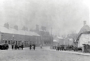
Up end at the junction of Bunyan Road and St. John's Road about 1900 [ref: Z50/67/15]
Population
(note that the figures for 1801 and 1851 include the modern parish of Kempston Rural)
1801: 1,035 1851: 1,962 1901: 4,729 1951: 8,645 2001: 19,375