Blackburn Hall Farm Thurleigh
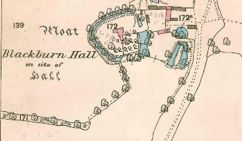
Blackburn Hall in 1884
In May 1952 Blackburn Farmhouse was listed by the Ministry of Works as Grade II, of special interest. They dated the building as 16th or 17th century, though situated within a medieval moat. There is now some evidence that the core of the building may be medieval too. It is mainly of timber-framed construction beneath colour-washed plaster but in some places colour washed brick has replaced the timber-framing. There is an old clay tiled roof. The building is in a T-shape, of two storeys with a cross-wing containing a possible first floor hall, which would be in the oldest part of the building.
The house stands on or near the site of the manor house for the Manor of Thurleigh alias Blackborne Hall and its ownership reflects that of the manor, passing from the Fitz Geffrey family to Sir Nathan Wright in 1707 [WG585-587]. It was sold by Nathan Wright the younger to Robert and Richard Bell in 1733 [WG594-595]. Mary Bell married William Gery in 1763 [WG874] bringing the manor into the Wade-Gery family, Rev Hugh and his wife Hester Wade-Gery settling it on their son William Hugh in 1829 [WG1292].
In May 1919 both Blackburn Hall, or Black Bull Hall, and Romp Hall Farms were offered for sale by auction. Title to the two farms began with a mortgage taken out by Peter John Locke King with William Hugh Wade-Gery in 1872. The sale particulars [Z720/1/30] described the farmhouse as “the old-fashioned moated residence occupying the site of the original hall”. The residence contained a porch, a bricked hall, two sitting rooms, a breakfast room, a store room, a scullery with an open hearth, a sink, pump and baking oven, a dairy, four bedrooms, a dressing room and box room. Outside stood a wood barn, a coal house and a boiling copper. There were also: “flower and kitchen gardens stocked with fruit trees”. The homestead comprised: a four-bay cart shed and closed gig house; a granary; a barn; a hen house; a two bay open shed; a loose box and three piggeries; a loose box and carthorse stable; a “loose place”; a cow house for ten beasts; three calf boxes; a corn barn and three yards. The farmland comprised 189 acres, 2 roods, 16 poles of which about 104 acres was arable and 84 acres pasture. The tenant was Charles Jordan who paid rent of £130 per annum.
The farm was still in the wade-Gery family in the 1920s. The Rating and Valuation Act 1925 specified that every building and piece of land in the country was to be assessed to determine its rateable value. The valuer visiting Blackburn Hall Farm on 15th March 1927 [DV1/H21/70] found that the owner was R. Wade-Gery and the occupier C Jordan whose rent of £184 for 184 acres had been fixed in 1910. The valuer noted: “Came in 40 years and has continued ever since, no proper road, no metal at all, can't get out in winter, buildings very bad, has done up recently, no water from tank, buildings from pond, leaving at Michaelmas perhaps". He also noted: "A very bad homestead - three thatched ranges one barn thatch all off. Worst buildings I have seen. House very fair just done up outside. Land poor, wet, neglected. In fields approaches very bad".
The house comprised two parlours, a living room, a kitchen, a dairy and five bedrooms. Outside were: a hen house; a two-bay hovel; four loose boxes; another loose box; a four-stall stable; an old cow hovel; a loose box; a barn; an old hovel; a four-bay cart shed; a granary and a barn in very bad repair.
The Bedfordshire Historic Environment Record [HER] contains information on the county’s historic buildings and landscapes and summaries of each entry can now be found online as part of the Heritage Gateway website. The listing for the moated site [HER 309] notes that the site consists of a medieval moat, fishponds and quarries associated with Blackburn Hall. The moat is almost circular, and measures about 80 metres by 75 metres. The central island is surrounded by a moat 12 metres wide and widening out on the south-east to form a pond. It is about 3 metres deep, with permanent water on the eastern side. A bank on the outer edge of the northern and western arms measures 5 metres wide and up to half a metre high. The moat is crossed to the east and west by causeways. The island includes a raised platform half to one metre high with a central hollow in which the house stands. Foundations of ancillary buildings have been found during excavation for a swimming pool.
A pair of fishponds is located 10 metres to the south-east of the moat, about 32 metres long and 12 metres wide on either side of a small banked island. The ponds are surrounded to the north and east by a ditch. To the north-east of the moat are two water-filled hollows 30 metres by 12 metres and believed to be very deep. They have been identified as quarries, the likely source of building material for the house.