Sweetbrier Farm Old Warden
Monastic roots
Founded in 1135, the Cistercian abbey of Wardon had two home farms in the parish of Old Warden/Northill. When the abbey surrendered to Henry VIII in 1537, Park Grange boasted at least 243 acres of meadow and pasture and 414 acres of arable, plus farm buildings and outbuildings [BHRS, 64, 149-50 (429)]. The grange was leased to Thomas Lawe, bailiff of Olney, on 16 May 1539. It was then granted to Anthony Lawe by Princess Elizabeth on 8 August 1555 and the lease reissued by her as queen, effective 25 March 1562.
On 16 June 1569 the Crown leased ‘the house and site of the Monastery of Wardon’, Park Grange, and tithes to Arthur Grey, 14th Baron Grey of Wilton (1536-1593) for 31 years [Cal. Pat. R., Eliz I, vol. 4, p. 343]. In 1587/88 they were granted to Sir Charles Morison of Cassiobury (Herts) and when he died on 25 July 1599, his extensive landholdings in Bedfordshire, Hertfordshire and London passed down to his son, Charles [VCH Beds, vol. 3, p. 253; Old Warden and Southill, f.145 [CRT100/5].
On 4 July 1629 the lease for the manor of Warden (except for the site of the late abbey, Park Grange, and other specified assets) was sold to Robert Palmer of Hill and son William [W2223] and from that point onwards, the site of the abbey and Park Grange descended separately from the manor until 1786.
Farms in the 18th century
By summer 1750 the former Park Grange had been subdivided into nine separate farms as illustrated on the Map of the Estate of Miss Katherine Davis Bovey situate in the Parishes of Old Warden and Northill in the County of Bedford c. 1750 [Z1125/1], but these were just a fraction of the assets acquired by Thomas Alston (1724-1774) through his marriage to Katherine on 29 August 1750. On 2 January 1759 Thomas succeeded as the 5th Baronet Alston of Odell. Despite the couple being estranged, Katherine assumed the title of Lady Alston and her estates, including those in Bedfordshire, remained the property of her husband.
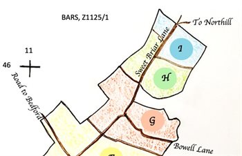
Key to Z1125/1, 'Map of the Estate of Miss Katherine Davis Bovey situate in the Parishes of Old Warden and Northill in the County of Bedford'
Illustrated on the key to the 1750 map, three of Alston’s farms sat on top of the Greensand Ridge [G], [H] and [I]. One [Farm G] lay entirely in the parish of Old Warden, whereas [H] and [I] were situated partly in Warden (north-west of Sweet Briar Lane) and partly in Northill.
In 1770 tenant Richard Savill contributed 3s 7d towards poor relief for Old Warden and paid £1 16s 5½d in land tax for Deadmans Oak [Farm I], which had previously been held by his friend Samuel Sutton [PE194; PE195]. Savill only paid the flat rate of window tax (3s) as the farmhouse had ≤6 windows [PE196]. Oak Farm now occupies the same site [OS Grid ref: TL 1283 4654].
In 1770 Henry Inskip (1715-1773) contributed 7s 11d in poor relief and paid £3 12s 11d in land tax for SWEETBRIER FARM [H], which had previously belonged to Robert Sutton. In common with Deadmans Oak, the small dwelling contained ≤6 windows. This is now the site of Sweetbrier Cottage [OS Grid ref: TL 1255 4608]. Henry Inskip also paid £2 8s 5d poor relief for his unnamed farm [G] and £14 6s 8½d in land tax. The window tax bill came to £1 5s 6d (3s flat rate plus 18d for each of his 15 windows). The outbuildings belonging to Inskip’s farm were just a few metres north-west of the present-day Sweetbrier Farm [OS Grid ref: TL 1232 4527].
Sir Thomas Alston died in 1774 and his widow Katherine recovered her estates. After her death in 1778, these were held in trust until John Wasse (her eldest son through her longstanding relationship with John Wasse senior) came of age in July 1781. Lawyers became involved as Wasse recovered the entailed lands and on 27 May 1782 and 28 July 1785 William Lamb is documented as the tenant of both Deadmans Oak and SWEETBRIER FARM (known as Sweetbrier Lane Farm [W2323 & W2346]). Henry Inskip (1748-1801) had succeeded his late father at the ‘farmhouse in Warden Street’ with closes [Farm G]. The laborious legal proceedings ended on 19 June 1782 and Wasse was finally in a position to sell [W2324 & W2325].
In July 1786 brewer and Samuel Whitbread (1720-1796) paid £19,600 to complete the purchase of ‘a messuage in Warden Street, Old Warden, known by the name of the Abbey, and closes adjoining, in the occupation of Samuel Sutton’, and a number of other farms including the abovementioned Deadmans Oak and SWEETBRIER FARM [W2346 & W2350-W2351]. Nine farms are listed by name and area in a marriage settlement of 12 January 1788, which shows Deadmans Oak Farm (89 acres 2 roods 27 perches), SWEET BRIAR FARM (92-3-22), and Inskipps Farm [sic] (177-2-29) [W3315].
Restructuring took place after 1788 and it seems that Inskipps Farm was amalgamated with SWEET BRIAR FARM. At some point, certain lands passed from Samuel Whitbread, son and heir of Samuel Whitbread (deceased) to Sir Thomas Miller of Froyle Place (Hants), but as part of a land exchange dated 20 February 1809 Miller returned the ‘messuage or farmhouse in Warden Street and lands appertaining (254 acres), late in the occupation of Henry Inskip, now Anne Inskip; with tithes; lands are parcels of 2 farms called Sweetbriars lane farm and Deadman’s Oak farm’ [HY469-70]. These parcels can be identified using the names/numbers from the 1750 map.[ See 'Map of the Estate of Miss Katherine Davis Bovey' by Margaret Roberts].
In Old Warden - from Inskipps Farm Creamer’s close [G2], Little Mary Slade [G13], Great Mary Slade [G12], piece of wood adjoining [G11], Lower Slade [G10], piece of wood adjoining [G9], Great Wood close [G8], Wood close [G7], Middle close [G6], Home close [G5], High field [G4], and Park field [G3];
In Northill - from Sweet Briar Farm Great Trayleys next Sweet Briar Lane [H1], Great Trayleys south of last [H2], Pond Trayleys [H3], Lower, Upper and Little Trayleys [H4-H6]; and from Deadmans Oak Farm Horse close [I13], Hungerhill field [I11], 2 pieces of wood adjoining [10], Great Cook’s field [I7], Bushy close [I8], Gravel close [I9], Home close [I4], Little Cook’s field [I6].
Excluded from the deal were all of the closes north-west of Sweet Briar Lane in the parish of Old Warden.
The above text was written by Margaret Roberts, Volunteer Historian, Warden Abbey Vineyard.
Sweetbriar Farm from the 19th century onwards
In 1809 Whitbread sold Sweetbrier and the neighbouring Highlands Farm to William Walker of Highlands Farm for £8,167 [HY471-472]. In January 1825 Walker sold two farms called Highlands and Sweetbrier, the former "newly erected", to Jeremiah Rosher of Northfleet [Kent] for £17,490 [HY474-475]. William Rosher sold the farms to John Harvey of Ickwell Bury for £20,000 in October 1858 [HY478-479]. At that date Sweetbrier Farm was depicted on the map below (to see a larger version please click on the image).
![Sweetbrier Farm in 1858 [HY478]](/CommunityHistories/OldWarden/OldWardenImages/Sweetbrier Farm in 1858 [HY478]_350x263.jpg)
Sweetbrier Farm in 1858 [HY478]
The land was scheduled as follows:
1. Homestead: 2 acres
2. Sheep Leys and 3. High Field or Horse Close: arable and now in one field of 17 acres, 3 roods, 8 poles
4. Park Field: arable of 6 acres, 1 rood, 35 poles;
5. Home Close: pasture of 10 acres, 18 poles;
6. Middle Close: pasture of 9 acres, 3 roods;
7. Wood Close: arable: 11 acres, 3 roods, 6 poles;
8. Great Wood Close: arable: 27 acres, 3 roods, 3 poles;
9. Spinney of 1 acre, 1 rood, 20 poles;
10. Mary Slade: pasture: 4 acres, 1 rood, 2 poles;
11. Part of Mary Slade: pasture: 1 acre, 30 poles;
12. Greens Hill: arable: 27 acres, 2 roods, 4 poles;
13. Spinney of 1 acre, 3 poles.
Total 121 acres, 0 roods 9 poles
In December 1876 John Harvey made an agreement with Joseph Shuttleworth [SL1/151]. He had lately made up Warden Street as far as Sweetbrier Farmhouse and the two men divided the road into lengths that each would maintain.
The Rating and Valuation Act 1925 specified that every building and piece of land in the country was to be assessed to determine its rateable value. The valuer visiting Sweetbrier Farm [DV1/H50/54] then found it owned by the Shuttleworth Estate, who must have bought it from the Harvey family. The occupier was Ben Larby who had paid rent of 15 shillings per acre rent before the Great War, a figure raised to 18/6 per acre from 1925 and so totalling so about £160 for 172 acres.
The valuer commented: "Long way from high road. House and buildings very old, mostly thatch, badly off for water, only shallow well, some wet, heavy land". Another hand wrote, on 27th January 1927: "A good house – plenty of homestead but expensive. Lot of thatch. New double shed. [Ordnance Survey Map numbers] 292, 308. 289 useful land buy position bad. Note Landlord repairs. Game a curse".
The farmhouse comprised two living rooms, a kitchen, a dairy, two store rooms, five bedrooms and two attics. The valuer commented: "Very old house". The homestead comprised the following:
- West Block: stabling for six horses; four pigsties; two henhouses and a loose box;
- North Block: two large barns; a large chaff house; a mixing house; a cowshed for eight and six calf boxes.
- East Block: an implement shed; a loose box; an open hovel and a granary.
"All wood and thatch very old require a lot of keeping up"
The farmhouse was listed by the former Department of Environment in March 1985 as Grade II, of special interest. The department dated the property to the 17th century noting that it had probably been re-fronted in the 18th century. It is built of colourwashed roughcast over a timber frame and has a clay tiled roof, hipped to the south and east corners. It is built in a U-plan, the front block having two storeys, the cross-wings two storeys and attics.