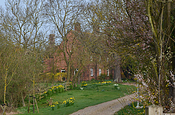
Parsonage Farm Shillington

Parsonage Farm April 2015
Parsonage Farm was listed by the former Department of Environment in July 1975 as Grade II, of special interest. It dates from the 16th century "or earlier" though reworked in the 19th century when re-skinned in red brick over the very substantial timber frame. It has a clay tiled roof. The central two storey block has slightly lower two storey wings projecting to north-east and south-west. One room contains 18th century panelling.
The farm, as the name suggests, was part of the Manor of Shillington Rectory, held by Trinity College, Cambridge from 1547 which may have been around the time the house was built. In 1804 a survey was carried out of all the manor holdings including Parsonage Farm [HA771]. Shillington was inclosed in 1817 so at this date the medieval farming system of a few large open fields containing furlongs and strips in multiple ownership still held sway. The total area of the farm was 209 acres, 2 poles and value was £242/15/6. The tenant was Widow Dearn and the individual units were as follows:
In Town Field
- Ruttingham Roods and Great Chadwell: 29 acres, 2 roods, 37 poles - £32/7/6
- Little Chadwell: 9 acres, 1 rood, 21 poles - £9/4/0
- Gallows Corner: 5 acres 3 roods 27 poles – £5/6/0
- Long Roods: 3 acres 1 roods 17 poles - £3/0/6
- Newditch Baulk and Irvines Haydons: 2 acres 3 roods 5 poles - £2/11/6
- Part of New Ditch: 5 acres 1 roods 35 poles - £4/18/6
- Town Common: 23 acres 2 roods 9 poles - £27/19/-
In Aldike Field
- Long Sutton: 21 acres 2 roods 35 poles - £21/14/6
- Old Field: 13 acres 0 roods 17 poles - £12/9/-
- Rowditch and headlands: 13 acres 0 roods 22 poles - £11/19/-
- Duck Riddy: 15 acres 0 roods 38 poles - £13/14/-
- The Common: 2 acres 1 roods 22 poles - £2/17/-
[Inclosed lands]
- Number 45, late Lord Glastonbury: 4 acres 2 roods 34 poles - £8/5/-
- Number 97 Gold Mead: 4 acres 3 roods 35 poles - £6/14/-
- Number 99 The Park: 7 acres 1 roods 2 poles - £14/3/-
- Number 100 The Parsonage Yards etc.2 acres 2 roods 10 poles - £5/2/6
- Number 101 Meadow: 3 acres 1 poles 32 roods - £6/8/-
- Number 98 Meadow:3 acres 0 roods 12 poles - £5/1/6
Church Hill: 10 acres 2 roods 16 poles - £16/9/6
Church Bridge: 26 acres 2 roods 16 poles - £32/13/6
The Rating and Valuation Act 1925 specified that every building and piece of land in the country was to be assessed to determine its rateable value. The valuer visiting the farm on 30th July 1926 [DV1/H7/6] found that the owner was still Trinity College, Cambridge. The occupiers were Benjamin and Robert Hempstead Brown who paid rent of £343/16/- per annum which included included five cottages, the farmhouse and homestead and 440 acres. He noted: "Plenty of roads but very bad in winter. Can't ever get dry away from building, water laid on. Has all boundary hedges and not ditches to keep up". Another hand wrote: "back land 25 miles of hedges (so says Brown!)" and on 8 September 1926 another hand: "Buildings good. Allow one shilling per acre for extra ditching and hedging. Very useful land, but some badly placed. Bad to get at in winter. College rent – low". the Brown family had been at the farm since the 1890s.
The house comprised two reception rooms, an office, a lumber room, a kitchen, a scullery and parlour, a dairy, a cellar, a bathroom and five bedrooms. Outside was a wood shed, a store, a brick and slate poultry house and stable and a garage. The valuer commented: "very nice garden"
The homestead was divided into four blocks with outlying buildings:
- Homestead south: a brick and tiled piggery, a store, a stable (for nine horses) with a chaff house and a harness room;
- Homestead west: a brick and tiled loose box, a loose box with a granary over, a two bay cart shed and a barn
- Homestead north: a six bay open shed, a store, a cow house for six beasts and a loose box
- Homestead east: a brick and slate poultry house; a brick, wood and corrugated iron shed, a mixing house and three wooden pigsties;
- Yard: a brick and tiled nine bay open shed; a five bay open shed; a wood and corrugated iron open implement shed; a wood and tiled granary and a wood and corrugated iron lean-to shed;
- A Webster oil engine used for supplying water to homestead;
- The field with Ordnance Survey Map number 347 contained a large barn ("poor");
- In another field: two barns and two yards in very bad condition, the valuer commenting: "Absolutely useless except to keep stock";
- At Parsonage Farm (presumably near the house): a brick and tiled store with a loft over; a cow house; a nine bay open shed; a cow house for three; a loose box; a wood and tiled poultry house ("very old") and a brick, wood and tiled nine bay implement shed
In 1974 it was proposed that an outbuilding be converted into a dwelling [PL/P/MB74/777] proposed conversion of outbuilding to dwelling.