Old Roads from Carlton & Possible Early Settlement
This content was contributed by Pamela Hider
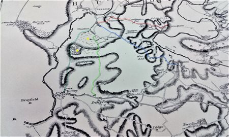
Taken from Jefferys map of 1765 (click for larger version)
- --- Road to Pavenham
- --- Road to Stevington
- --- Roads to Turvey
- Yellow spots indicate the Church and Carlton Hall
- Brown marks indicate early settlement
'Villages in the Landscape' by Trevor Rowley (1978) tells us that "The Church will normally be the oldest standing structure in the village, and will embody the whole development of the village, sometimes right through from the late Anglo-Saxon period.......Next to the church the manor house or hall-garth (meeting place with garden) is the most common large building in the community". The manor house might have been distinguished from other houses by being moated and from the 15th century would have been rebuilt and often resited.
Such a setting could describe Carlton Hall (a little west of St.Mary's church), which over time was both rebuilt and resited a little east of the church and renamed Stayesmore Manor. William Stayesmore followed by John Stayesmore were at Carlton Manor in the early 16th century and it would seem their name endured. Land ownership, normally controlled by the Lord of the Manor, would influence the development of the village in terms of location of buildings and roads.
In Carlton, this took place principally in the High Street which was nearest to both church and manor house and where most of the oldest houses are to be found today. A track behind the west side of High Street leads across fields directly to the church and across the main road continues south across fields up to Northey Farm. Earthworks around these tracks are suggestive of buildings from an earlier period.