Keysoe in Prehistory

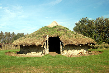
A reconstruction of an Bronze Age round house at Flag Fen October 2011
The Bedfordshire Historic Environment Record [HER] contains information on the county’s historic buildings and landscapes and summaries of each entry can now be found online as part of the Heritage Gateway website. Prehistoric sites in Bolnhurst are generally confined to cropmarks, which show disturbances of the soil due to ancient banks, ditches and walls. There is, however, one more precisely dated site.
The earliest datable features in the landscape are two circular features known as ring ditches south of Hardwick End. These are Bronze Age in date and usually represent barrows or, perhaps, large circular huts [HER 16626]. The ditches are about 100 metres apart on a north-east facing slope and one is larger than the other.
Other sites which may, or may not, be prehistoric are as follows. In these cases field walking or excavation would be necessary to determine a more precise date span:
- A block of rectangular enclosures is located south-east of Hatch End [HER 13743];
- A rectangular cropmark with a possible circular hut inside, the entrance facing south-west, lying north-west of London End, Keysoe Row East [HER 15016]. The cropmarks are located on top of a north-west facing spur between two watercourses [HER 15016];
- Three sides of a square or rectangular enclosure are identified at the north end of Keysoe Park Wood, each line is about 100 metres long and the feature crosses the modern parish boundary into Riseley [HER 16620];
- An irregular enclosure with a trackway entrance can be identified as a cropmark south of Hatch End [HER 16678];
- A group of curved cropmarks lies east of College Farm. In 2007 a small development nearby in Keysoe Row West did not turn up any artefacts [HER 16679];
- A rectangular enclosure with a line attached is identified as a cropmark west of Keysoe Row East [HER 16680];
- A complex group of cropmarks lies north-east of College Farm [HER 16681];
- A scatter of small enclosures, with interlinking features can be observed as cropmarks south of the church [HER 16682];
- A rectangular cropmark has been identified on top of a north facing spur south-east of Doddshole Farm [HER 16683].