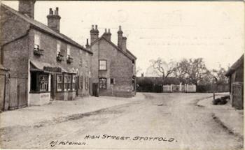
The Parish of Stotfold in General

Stotfold [ref: Z1306/115/3/10]
Stotfold is an ancient parish and small rural town in Central Bedfordshire in the east of the county. Stotfold is south of Biggleswade and on the border with Hertfordshire. The town covers 2,207 acres and the river Ivel passes through it.
Landscape
Volume II of The Victoria County History for Bedfordshire was published in 1908; at that time the parish comprised 2,398 acres, of which 1,890¾ were arable land, 302¼ permanent grass, and 8 woods and plantations. The soil is made up of light clay with beds of gravel, the subsoil gault. The chief crops were wheat, barley, beans, and potatoes and market-garden produce.
Name
Although there is no unanimous agreement as to the meaning of Stotfold. It is widely believed that the name derives from the practice of cattle drovers who would break up their journey along the A1 Great North Road and pen the cattle or horses (stots) in enclosures (folds) before they continued their journey. There is also a suggestion that the name means “An Estate Enclosure” from the Anglo-Saxon word Stat, meaning an Estate. Compared to other parishes there has been very little variation in the spelling of Stotfold.
- 1007: Stodfald
- 1086: Stotfalt
- 1198: Stotfald
- 1199: Stotfold
- 1200: Stotfaud
- 1202: Stofaude
- 1227: Stodfold
- 1227: Stodfauld
- 1287: Stotfolt
- 1343: Stottesfold
- 1580: Statfolde
- 1780: Statfold
Administrative History
Stotfold is an ancient parish in the Clifton Hundred which includes: Arlesey, Campton, Clifton, Holwell, Meppershall, Shillington and Upper Stondon. The parish borders Hertfordshire. There are two tiers of local government covering Stotfold, at parish (town) and unitary authority level: Stotfold Town Council and Central Bedfordshire Council. When elected parish and district councils were created in 1894 it was given a parish council and included in the Biggleswade Rural District. In 1974 the Biggleswade Rural District was replaced by Mid Bedfordshire. At the same time, parish councils were given the right to declare their parishes to be a town, which Stotfold did with effect from 1 April 1974. Mid Bedfordshire and Bedfordshire County Council were both abolished 2009, when Stotfold became part of the unitary authority of Central Bedfordshire. The parish of Stotfold historically included the Fairfield area, which was made a separate parish in 2013.
Population
The Domesday Book of 1086 contains an entry for Stotfold listing a total of 21 villagers, 14 smallholders and 6 slaves. As these individuals would have been heads of households, this number should be multiplied by at least four to provide an idea of the actual figure. Stotfold has seen a steady increase in its population.
The Hearth Tax of 1671 records 82 dwellings in Stotfold for a total of 152 hearths. It has been estimated that this represented a population of about 357. The largest number - 12 - were in the house of William Abbice, gent. Two houses are noted as containing a forge.
Population Figures
- 1086: 200
- 1671: 357
- 1801: 494
- 1851: 1,395
- 1901: 2,768
- 1921: 3,197
- 1951: 5,153
- 1991: 6,434
- 2001: 6,107
- 2011: 9,520
- 2021: 12,308
List of Sources at Bedfordshire Archives:
- P83: Stotfold Parish Records
- PCStotfold: Stotfold Parish Council Records
- Z50/115: Stotfold photographs
- Z1130/115: Stotfold postcards
- Z1255: Photographs of Stotfold, 2006
- Z1306/115: Stotfold postcards