The Parish of Battlesden in General
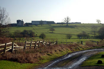
Hill Farm ridge from the centre of the village January 2008
Landscape
Volume III of The Victoria County History for Bedfordshire was published in 1912. At that date Battlesden consisted of 1,148.5 acres of which a third was arable, growing wheat, barley, oats, beans and peas and two thirds permanent grazing, there only being eight acres of woodland.
The landscape is divided by the valleys of three south-west flowing streams; those to north and south largely followed by the parish boundary; the centre stream is called Village Brook. The solid geology is Gault Formation, a sedimentary rock known as mudstone, formed between 99 and 112 million years ago during the Cretaceous Period when the area was under warn, shallow seas. The superficial geology is largely till, though there is an area of head (a mixture of gravel, sand, silt and clay) to the east, west and south of the village.
The parish averages around 400 feet above sea-level. The church stands at around 445 feet and Centre Farm at around 405 feet. The land falls away towards the A5 and Battlesden Lodge stands at around 360 feet above sea level.
Name
The name first occurs in the Domesday Book of 1086 as both Badelstone and Badelsdone. The name has had a large number of variations over the years including the following: Badelesdun (c.1160-1220); Badelesden (1227-1287); Baddelesdon (1242); Badlesdon (1247-1361); Batlesden (1254-1428); Battilsden (1257); Baddesdon (1284); Badlesden (1287); Baddelesden (1287); Batelesdon (1347-1348); Badleston (1348-1391); Batelesden (1389-1489); Badlysdene (1390-1392); Badlysden (1562); Batellesden (1535). Sadly, the name has nothing to do with a battle, the first part of the name being the Anglo-Saxon personal name Badel; the second part being the Old English word "dun" meaning hill - thus "Badel's hill".
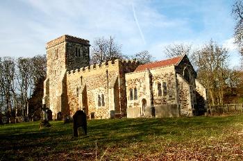
Battlesden church from the south-east January 2008
Administrative History
Battlesden is an ancient parish and remains a separate civil parish but for ecclesisatical purposes was united with Potsgrove (as Battlesden with Pottesgrove) in 1928. The united parish is now part of a group of churches also including Woburn with Eversholt and Milton Bryan.
The boundary of the civil parish was revised in in 1984. This is because of the somewhat unusual boundary with Hockliffe along the Watling Street, the modern A5. A number of houses, including the former Swan public house, although part of the settlement of Hockliffe, were in the parish of Battlesden, the boundary zig-zagging oddly so that one property on the east side of the road might be in Battlesden whilst its neighbours to north and south were in Hockliffe. Hockliffe Lower School was also, officially, in Battlesden. This rather anomalous situation was corrected bt the Bedfordshire (Areas) Order 1984 [CDP81] when all the properties along the east side of the A5 were transferred into Hockliffe. The whole of the shaded area on the map below being the area affected.
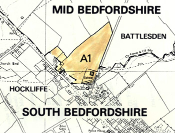
Boundary change between Battlesden and Hockliffe in 1984 [CDP81]
Roads
Battlesden is bordered by two major roads, the old Roman road of Watling Street and the road running from Hockliffe to Woburn. Both of these would have required considerable expenditure from so small a parish population to keep them in repair. It must have been a relief, therefore, to the parish rate payers when they became the first two turnpike roads in the county in 1706; the money for keeping them in repair being then raised by tolls administered by the turnpike trustees.
The present course of the Woburn road dates from the early 1830s when it moved somewhat east of its old course. The old line is still partially visible at times as crop marks in the neighbouring fields. The act responsible for turnpiking the road in 1706 noted: "...that the lane called Hockley Lane in the parish of Battlesden...was only a common footway, horseway and a way for driving cattle and there has been made at a very great expense and constantly maintained by the parish of Battlesden a large and substantial causey [causeway] for the passing of horses and drift cattle...although the said lane was no ancient or common highway for carts and carriages yet being very broad if the same lane...then very ruinous and almost impassible could be mended and made good it would then be the most convenient passage for carriages to Woburn".
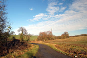
Site of the gasworks January 2008
Population
It is interesting to note that Domesday Book records a total of twenty men as tenants of the various landowners in Battlesden in 1086. To get a full population figure one should multiply this by at least a factor of four to account for the men's dependents, giving a total population of around 80, about the same as parishes which, today, have a much greater population, such as Aspley Guise, and more than twice the modern population of Battlesden.
Since Domesday, so far as historical records can tell us, Battlesden seems never to have been a well populated parish, presumably because of the relatively poor quality of the soil for ancient ploughs. The Hearth Tax of 1671 [BHRS volume 16] records only thirteen householders with two people receiving alms from the parish. A total of 44 hearths were recorded (including one empty house of three hearths), but 13 of them were in Battlesden House, two houses had five and six hearths and three houses had three.
Volume 81 published by the Bedfordshire Historical Records Society (2002) is devoted to returns made during episcopal visitations to the county by the Bishop of Lincoln in the early 18th century, edited by former County Archivist Patricia Bell. One of the questions asked was the number of nonconformist families in the parish; the various responses were as follows:
This small size has, in recent years, declined to a tiny size, as the following population figures show:
-
1801: 133;
-
1811: 130;
-
1821: 151;
-
1831: 145;
-
1841: 179;
-
1851: 160;
-
1871: 167;
-
1881: 114;
-
1891: 81;
-
1901: 72;
-
1911: 66;
-
1921: 71;
-
1931: 60;
-
1951: 71;
-
1961: 54;
-
1971: 43;
-
1981: 40;
-
1991: 34;
-
2001: 38.
-