Ordnance Survey Maps of Battlesden
To see larger versions of these 25 inches to the mile Ordnance Survey maps please click on the relevant thumbnails
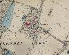
1st Edition of 1882

Centre Farm and village, note the Suday School and the row of cottages at the bottom of the map on the from the village centre south described in 19th Century Battlesden
Battlesden House and church
2nd Edition of 1901

Centre of village and farms; note the properties which have disappeared since the 1882 map
Battlesden House and church