19th Century Battlesden
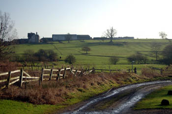
The track from the centre of the village to Hill Farm - in the early 19th century this road had a number of cottages on the right hand side
It is easy to stand in the middle of Battlesden today and think oneself miles away from anywhere, in a spot as remote as any on Dartmoor or the North York Moors. However, Woburn and Hockliffe are only about two miles away and the large conglomeration of Dunstable and Houghton Regis only about double that. The reason, of course, is the very depopulated nature of the village which even as late as the end of the 19th century had rather more houses than today.
Bedfordshire Archives has a wonderful series of photographs of paintings from the collection of the former Lords of the Manor, the Page-Turner family. They show Battlesden House and other houses in the village, including three paintings of views over the village by Thomas Fisher, one with a number of cottages on the road from the centre of the village to Hill Farm, another with just one cottage remaining. Sadly, these may not be copied but may be viewed in the office - series reference Z102.
It is often supposed that the painting showing a number of cottages is earlier than the one showing just one and that they were knocked down in the intervening period. Following some research in answer to a question former County Archivist Chris Pickford came to a different view [ref: CRT130Battlesden8]: "The puzzle of the Battlesden cottages is one which has troubled several people over the years and, of course, the problem is caused by the fact that two out of the three Fisher paintings are undated. the one which bears a date is our Z102/111 which shows the view from the South East towards the church and House without the cottages. The existence of the picture of the "cottages formerly in the village" [a series of frontages of these cottages taken out of their context] and the view which shows a row of cottages along the lane near Hill Farm has, I think, confused people into thinking that the cottages which were pulled down in about 1818 were those shown on the undated view. The map evidence leads me to think that this is a hasty assumption, and that in fact the row of cottages near Hill Farm was built in about 1820 to replace others in the village which had then recently been demolished..."
A map by Thomas Jefferys of 1765 shows the main habitation in Battlesden in the sharp bend of the road between Centre Farm and the road leading to the church, as shown in the blue hatched portion of the map below. The cottages shown in the Fisher painting were along the road from the centre of the village heading south, some way south of this main part of the village (the thicker black line below on the sketch plan).
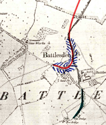
Sketch map accompanying CRT130Battlesden8
On the Tithe Map of 1845 these cottages on the road heading south were still there and were described as: "8 cottages and gardens". The map also showed two more cottages [numbered 39 and 41] which appeared on the 25 inch Ordnance Survey map of 1882 but had been pulled down by 1901. The cottages on the track heading south, again, are shown on the 1882 map but not the 1901 map, showing they had been pulled down by then. Census returns for Battlesden show the population fell from 114 in 1881 to 81 1891, suggesting that the southern track cottages were pulled down in this period.