The Parish of Shefford in General
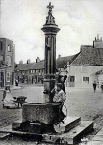
The parish pump about 1900 [Z1306/101]
Landscape
Shefford is dominated by the River Flitt which runs more or less through the middle, with the river Hit flowing into it from the south in the angle between Stanford Road, Northbridge Street and Southbridge Street, after which point the combined river becomes part of the River Ivel Navigation (although this is now disused as such). Volume II of The Victoria County History for Bedfordshire was published in 1908 and at that date the parish comprised 144 acres, 2 roods.
The highest point in the parish, 244 feet above sea level lies in the north, the lowest point, around 130 feet on the river near the windmill in the east of the parish. The Baptist church is about 133 feet above sea-level and the Anglican church about two feet lower. Shefford Hardwick Farmhouse stands about 150 feet above sea-level.
The solid, or underlying, geology of most of the parish is a form of greensand called Woburn Sands Formation. This sandstone was laid down between 99 and 121 million years ago in the warm, shallow seas of the Cretaceous Period. Along the south side of the middle of Ampthill Road, east of Ivel Road and south of Hitchin Road the solid geology is, by contrast, a mudstone called Gault Formation laid down at the same time as the greensand. Along the rivers the superficial geology is a mixture of sand, gravel, clay and silt, a fine alluvium close to the rivers and a coarser river terrace deposit further out. North-weast of the village is a mix of sand, clay, gravel and silt called head.
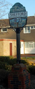
Shefford town sign February 2008
Name
The name Shefford first occurs in a lists of subsidies collected by the Diocese of Lincoln. The name is then rendered as Sepford - from the Old English "sceap ford" or "sheep ford". Later variations include the following: Shipford (1229); Shepford (1247); Sefford (1247-1251); Schefford (1262-1271); Cheford (1276-1361); Sheford (1276-1297); Schyford (1287); Chyford (1287); Schepeford (1307). The modern form is found as early as a feet of fines from 1262.
The name Hardwick in Shefford Hardwick means sheep farm.
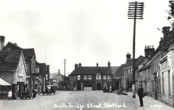
Northbridge Street about 1925 Z50-101-3
Administrative History
Shefford was originally a township, lying in the ancient parish of Campton. It became a separate civil parish in 1866 and a separate ecclesiastical parish in 1903. In 1866 the eastern boundary of the new parish lay along the river, making it a very small unit. In 1933, however, Shefford absorbed some of the western part of Clifton up to a line a few yards west of the boundary of the modern Samuel Whitbread Upper School.
Shefford Hardwick lies in the west of the parish, north of Ampthill Road. It was from early times an extra-parochial place, that is it did not lie in any ancient parish. It became a civil parish in 1858 but was taken into the parish of Shefford in 1933.
The modern parish of Shefford borders Clifton to the east, Meppershall to the south, Campton and Chicksands to the south-west and west and Southill to the north.
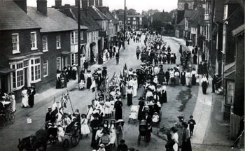
Band of Hope procession in High Street about 1914
Population
The Hearth Tax of 1671 (transcribed in Bedfordshire Historical Records Society Volume 16 in 1934) records 80 dwellings in Shefford for a total of 190 hearths. It has been estimated that this represented a population of about 370. The largest number - eight - were in the houses of William Stevens, Richard Stevens and John Mathew. The houses of Jonathan Chambers and Thomas Sutton the younger each contained a forge, clearly suggesting they were smiths. The houses of John Gigle and Richard Whittamore were empty. Nine persons in the township "received constant alms".
The population figures for Shefford and Shefford Hardwick rose fairly steadily during the 19th century, more than doubling between 1801 and 1851, and fell a little between 1881 and 1921 and then show a jump of over 100% between 1931 and 1951, partly due to new building and partly due to annexing the western part of Clifton in 1933. The big explosion in population has come in the last thirty years (nearly doubling in size) and Shefford today is more than ten times as well populated as two hundred years ago; in fact it has now the 13th largest population in the county.
The following letter from William Dickins, Overseer of the Poor for Shefford, to Samuel Whitbread gives evidence of medical services in Shefford in 1811 [W1/786/1-2]: "In Obedience to your order, I have inclosed the Population list &c of the Town of Shefford, and to inform you that the Medical Gentlemen of our Town take it yearly in Turns. Mr.Layman was appointed on Easter last, their salary a few years ago being Two Guineas, is now increased to three Guineas, to attend the Poor. Broken Bones, and Midwifery are paid (Extra) of the Parish Expence [sic]". The "inclosed Population list &c." reads as follows:
- Inhabited houses: 114;
- By Law many families occupied: 125 [this seems to be, in effect, the total number of families];
- Houses now Building: 3;
- Uninhabited Houses: 6;
- Families employed in Agriculture: 44;
- In Trade & Manufacture: 76;
- Other Families not comprised in the two preceding Classes: 5;
- Males: 245;
- Females: 291
- Total: 536
The population figures from the censuses are as follows:
- 1801: 474;
- 1811: 536;
- 1821: 618;
- 1831: 779;
- 1841: 902;
- 1851: 1,115;
- 1861: 1,071;
- 1871: 1,182;
- 1881: 1,123;
- 1891: 1,055;
- 1901: 936;
- 1911: 921;
- 1921: 979;
- 1931: 887;
- 1951: 1,873;
- 1961: 2,216;
- 1971: 2,683;
- 1981: 3,129;
- 1991: 3,234;
- 2001: 4,927;
- 2011: 5,581.