Wootton Before 1086

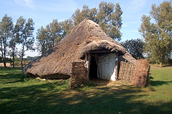
A reconstruction of an Iron Age round house from Flag Fen October 2011
The Bedfordshire Historic Environment Record [HER] contains information on the county’s historic buildings and landscapes and summaries of each entry can now be found online as part of the Heritage Gateway website. Four areas of the parish contain crop marks which may represent prehistoric occupation, though without further archaeological investigation it is impossible to be certain. North of Upper Shelton Road and south-west of Wootton Green Farm is an area of cropmarks including parallel lines and oval shapes [HER 14716]. North of Whitworth’s Farm [HER 16513] lies a large, roughly rectangular crop mark, 120 metres long by 90 metres wide. South-west of Vine Cottage is a possible crop mark which may show a roughly rectangular shape [HER 16548] and south of Bourne End Road is another possible crop mark representing an enclosure [HER 16549].
An area west of Canons Close [HER 13408] has produced a quantity of animal bones thought to be prehistoric in date as well as a flint core and two flakes and a quantity of pottery ranging from the early Iron Age to the Norman Conquest. A nearby area [HER 5570] may have produced an Iron Age jar and another jar which may be Iron Age or Romano-British, together with a flagon dating from the 2nd century AD. The three fragmented vessels were presented to the British Museum in 1969 by a resident of Canons Close and the assumption is that they were found in the vicinity.
A Roman coin minted at Alexandria in Egypt and dating from the late 3rd or early 4th century was found in the garden of 80 Mepham Road [HER 17729]. 2 Keeley Lane [HER 15804] seems to be the site of Roman occupation [HER 15804]. Several sherds of pottery were discovered in the front garden dating from the 1st century AD along with a small quantity of flint flake from the Iron Age and animal remains from the early Romano-British period. All this was found in what had been a ditch at the time.