Blunham Maps
The following maps are only a selection of those held at Bedfordshire and Luton Archives and Records Service. To see larger versions of each map, please click on the relevant thumbnail
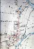
![Blunham Inclosure Map of 1799 [MA10]](/CommunityHistories/Blunham/BlunhamImages/Blunham Inclosure Map of 1799 [MA10]_67x101.jpg)
The Inclosure Map of 1799 [MA10]
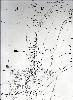
![Map of Blunham field names [CRT130Blu17]](/CommunityHistories/Blunham/BlunhamImages/Map of Blunham field names [CRT130Blu17]_71x100.jpg)
Map of Blunham field names [CRT130Blu17]
The central and northern areas of Blunham in 1884
The central and northern areas of Blunham in 1901
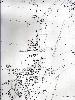
The central and northern areas of Blunham in 1926
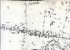
The area around Blunham Station in 1901