Husborne Crawley Maps
The following maps are only a selection of those held at Bedfordshire and Luton Archives and Records Service. The three maps below show Church End about 1760 [R1/42], in 1799 [MA75] and on the 1st edition Ordnance Survey 25 inches to the mile map of 1883. To see a larger version, please click on the appropriate image. It is noteworthy that Crow Lane already features on the 1760 map and, in fact, that the settlement seems to have changed relatively little in the century and more of the three maps.
![Church End in 1760 [R1-42]](/CommunityHistories/HusborneCrawley/HusborneCrawleyImages/Church End in 1760 [R1-42]_274x300.jpg)
Church End in 1760 [R1/42]
![Church End on the inclosure map of about 1799 [MA75]](/CommunityHistories/HusborneCrawley/HusborneCrawleyImages/Church End on the inclosure map of about 1799 [MA7_290x300.jpg)
Church End on an inclosure map of about 1799 [MA75]
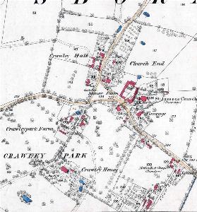
Church End in 1883
The two maps below show Turnpike Road about 1760 [R1/42], in 1799 [MA75] and on the 1st edition Ordnance Survey 25 inches to the mile map of 1882. To see a larger version, please click on the appropriate image. It is immediately obvious that in the just over eighty years between 1799 and 1882 virtually every house on the south-east side of Turnpike Road has disappeared. They were gradually acquired by the Duke of Bedford and demolished to be taken into Woburn Park. By the same token there are more houses on the north-west side of the road, cottages built by the Duke for his estate workers in the middle of the century. Again, to see a larger version, please click on the appropriate image.
![The area of Turnpike Road in 1760 [R1-42]](/CommunityHistories/HusborneCrawley/HusborneCrawleyImages/The area of Turnpike Road in 1760 [R1-42]_297x300.jpg)
The area of Turnpike Road in 1760 [R1/42]
![Turnpike Road on the inclosure map of about 1799 [MA75]](/CommunityHistories/HusborneCrawley/HusborneCrawleyImages/Turnpike Road on the inclosure map of about 1799 [_350x271.jpg)
Turnpike Road on an inclosure map of about 1799 [MA75]
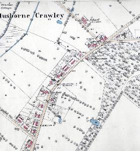
Turnpike Road in 1882