Bromham Before 1086
The Bedfordshire Historic Environment Record [HER] contains information on the county’s historic buildings and landscapes and summaries of each entry can now be found online as part of the Heritage Gateway website.
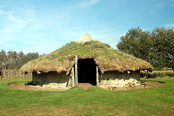
A reconstruction of a Bronze Age round house at Flag Fen October 2011
The earliest datable evidence for human activity in what is now Bromham comes from the Bronze Age. A ring ditch has been identified from aerial photography [HER 10144] north of the old railway line. Ring ditches are usually identified as the remains either of circular huts or round barrows. Other cropmarks south of the old railway [HER 561] also show a ring ditch, overlain by a rectangular enclosure with two ditches. The entry notes: “The area was ploughed heavily in the 1970s”.
More cropmarks have been identified on Mushroom Hill [HER 9085]. These have been dated to the Iron Age and comprise a large curved ditch. Simple excavation showed two rows of post holes and a large, shallow pit containing Iron Age pottery and animal bones. The curved ditch had a flat-bottomed U-shaped profile suggesting a boundary ditch. It also produced evidence of earlier activity from the Bronze Age.
In 2000 an excavation was carried out north-east of London Barn Farm [HER 16554]. Not much was discovered but an enclosure ditch was confirmed after identification by aerial photography. Finds from the ditch dated to the middle Iron Age.
Cropmarks east of Bromham Hospital [HER 3125] indicated another possible Bronze Age ring ditch as well as two linear features running up to it. Roman pottery from the 1st and 2nd century AD has also been found nearby indicating activity in the Bronze and Iron Ages and the Roman period.
A 1st century AD bronze brooch was found when field walking south of the village. It was shaped like a bow [HER14654]. Iron Age and Roman pottery has also been found in the village [HER 599]. Pottery dating from the Iron Age, through the Roman occupation and perhaps even into the Middle Ages has been found at 16 Grange Lane [HER 16182].
A Roman building was identified in 1937 at Moor End south of Thistley Green in what was then the civil parish of Kempston Rural [HER 245]. The building had stone foundations with wattle and daub infilling between timber posts. The roof had been tiled and tesserae were found indicating the presence of at least one mosaic. Pottery and coins found dated to the 3rd and 4th centuries AD. Pottery was also found on the surface in the early 1950s and field walking in 1982 revealed both Roman tile and pottery south of the site identified as a villa but much less to the north.
Thistley Lane and Thistley Green has been identified as an agger [HER 5156]. An agger is a minor roman road which shows as a linear feature tapering down from a central spine along the road to ditches at either side. A scatter of stones has been observed on the line of a proposed Roman road through the parish [HER 1500].
Three possible prehistoric sites have been suggested from aerial photography. One area is west of Oakley Road [HER 13975], one south of Mushroom Hill [HER 16564] and south-west of Bromham Plantation [HER 3123].