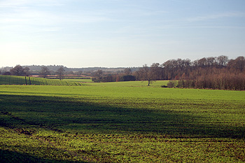
The view towards Carters Grove from Horsepool Lane Jaunary 2012
Two mills are mentioned in Husborne Crawley in the Domesday Book of 1086. Clearly, it is not known exactly where these were but it is possible that one of them was the mill later called Yppewell Mill whilst the other lay somewhere near the later mill on Mill Road. They would both have been watermills because windmills were unknown in England before the last quarter of the 12th century
Yppewell Mill is first mentioned in the Dunstable Cartulary [a collection of charters documenting the land owned and leased by Dunstable Priory] published as Volume X of the Bedfordshire Historical Records Society series in 1926. Entry 454 records an agreement between Woburn Abbey and Dunstable Priory about a number of mills, including that at Ypewell in 1227. The abbey promised not to enlarge the conduit behind their mill without negotiating with the priory.
A later entry, 488, which is undated but was written some time between 1205 and 1250 records land near the mill being given to Dunstable Priory by Nicholas de Tingry, one of the Lords of the Manor of Crawley, and, crucially, entry 490, again for an unspecified year between 1205 and 1250, reads: "N[icholaus de Tingri] grants a selion [a strip of arable land, sometimes one furlong long by one chain wide, though measurements were never exact] in Crawley above Yppewelle and near the prior's marl pit". In the notes to the Bedfordshire Historical Record Society volume the editor, first County Archivist George Herbert Fowler, states "Yppewelle Mill seems to have been at the Mill Farm in Husborne Crawley, the present Experimental Farm of the Royal Agricultural Society".
The 13th century reference to the marl pit is interesting and may suggest another location for Yppewell, backed up with evidence which Dr. Fowler would not have had available to him in 1926.
The Duke of Bedford's estate archive contains a map of 1819 [R1/226] detailing lands owned by him in Husborne Crawley and shows two pieces of land lying together, one called Marl Pit Close the other Mill Piece. These lie west of Turnpike Road and south-west of Horsepool Lane near a place called Carters Grove which lies on Crawley Brook. Today this lies in the civil parish of Aspley Guise though close to a point where the boundaries of Aspley Guise, Woburn and Husborne Crawley meet. It is difficult to be at all certain about the identification as about six hundred years passed between the two references but it is possible that Yppewell Mill lay somewhere near Carters Grove.
This hypothesis is reinforced by a coroner's inquest in 1269. Volume 41 produced by Bedfordshire Historical Records Society in 1961 is devoted to 13th and 14th century coroner's rolls for Bedfordshire from the National Archives, edited and translated by R. F. Hunnisett.
Entry 92 reads: "On 30th October 1269 Thomas son of Thomas Julian of Crawley came to the abbot of Woburn's mill called "Horssepol" in the parish of Husborne Crawley, opened the door and about prime allowed Hugh le Wannere to enter with a small sack full of malt. Thomas took some grease to grease the lower wheel of the mill with his left hand and stood too close to it so that the wheel held him and broke the whole of his left arm. Hugh, seeing this, shut the mill and shouted. Robert son of Muriel came and they rescued him alive and afterwards brought him to the house of his father Robert [sic]. He died after nones on the same day".
"Inquest before G. Rodlond, coroner, by Aspley Guise. Birchmore, Woburn Chapel, Crawley and Houghton Conquest: as above. The wheels with the upper stone, the rinds all the small utensils and the whole mill were appraised at 5 shillings and delivered to Crawley. Robert son of Muriel found pledges, William Acun and Hugh the Clerk, both of Crawley. Hugh found pledges, Walter le Teystur and Simon son of Henry, both of Crawley".
At the next eyre the dead man, then called Thomas, son of Thomas Galyon was said to have been greasing the inner wheel when he was crushed between it and the spindle. These two parts of the mill, worth 14/6 were adjudged deodand. Thomas was said to have died three days after the accident. Hugh le Brewere [sic] and Robert son of Muriel were attached because they were both present, they came to the eyre and were acquitted of any responsibility but they and their pledges were amerced because they did not attend on the first day and because they did not offer to go to prison although this was a case of death. One of Robert's pledges, Hugh the Clerk, had died in the meantime. The Abbot of won was amerced for taking the deodand without warrant and all the township except Woburn Chapel for appraising it falsely [they had undervalued it – 5 shillings as against the eyre's finding of 14/6].
Horsepool Lane still exists. It leads from Turnpike Road to Mount Pleasant in Aspley Guise. It thus runs within about a quarter of a mile of Carters Grove. This strongly suggests that the mill at Horsepool and Yppewell Mill are one and the same place.
One further reference to Ypewell exists in material held by Bedfordshire & Luton Archives & Records Society and that is a document from 1539 [Fac.1.SC6/HenVIII/30] in which it is recorded that Thomas Nicholls rented two watermills, one called Nichollsmyll and one called Ypwellmyll, from Woburn Abbey, which had been demised in 1535 for 20 years.
The final reference to this mill is probably in 1542 in a survey of lands forming the Honour of Ampthill [CRT100/25]. J. Grene was recorded as having one acre of land "in Brokefurlong in Clayefeild next the water mill in Crawley". This reference follows on from a reference to a messuage and close "next Horsepolelane in Crawley". The mill in Mill Road is not mentioned for another five folios and is shown on a map of 1760 [R1/42] as being in Mill Field and not Clay Field.