Studham Maps
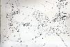
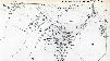
The following maps are only a selection of those held at Bedfordshire Archives. Note: to see a larger version of each map, please click on the thumbnail.
Ordnance Survey Maps Showing the County Boundary in 1880
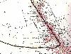
The county boundary in Markyate in 1880
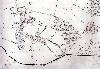
The main village in 1880
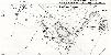
Other Ordnance Survey Maps of the 1880s

Common Road in 1880 (then in Hertfordshire)

Barwythe and Clements End in 1884 (then in Hertfordshire)
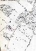
The area around Hill Farm in 1880
Ordnance Survey Maps of 1901

The main village in 1901

Common Road in 1901
Barwythe and Clements End in 1901
Ordnance Survey Maps of 1924
The main village in 1924

Common Road in 1924
Barwythe and Clements End in 1924

The area around Hill Farm in 1924