4 and 4a Dunstable Road Studham
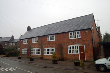
4 and 4a Dunstable Road January 2010
From 1880 to 1926 Ordnance Survey maps show that 4a Dunstable Road had no adjoining property to the south (today's Number 4). It is unclear whether the current 4a is the surviving building, albeit altered, or a newer construction, as map evidence shows a quite different footprint today to that from 1880 to 1926.
The Rating and Valuation Act 1925 specified that every piece of land and building in the country was to be assessed to determine the rates to be paid on it. Studham was assessed at the end of 1926 and the valuer visiting the property [DV1/C21/19] discovered that the owner and occupier was H. J. Gladman who ran a shop.
The brick and slate detached property comprised a kitchen, pantry, shop, measuring 9 feet by 15 feet and store room ("window used for show") measuring 11 feet 9 inches by 15 feet downstairs with three bedrooms upstairs. Outside stood a weather-boarded and corrugated iron barn. The valuer noted: "Sells sweets, groceries, tobacco, bicycle accessories" and "Face of house used as hoarding".