Little Barford Deserted Medieval Village
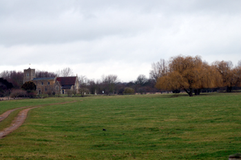
LIttle Barford Church and the site of the deserted Medieval village February 2010
Bedfordshire's Historic Environment Record [HER] contains details of every historic building and landscape feature in the county. It is now available on-line as part of the Heritage Gateway Website.
![Little Barford in 1765 [R1/110]](/CommunityHistories/LittleBarford/LittleBarfordImages/Little Barford in 1765 [R1-110]_349x173.jpg)
Little Barford in 1765 [R1/110]
The entry for Little Barford Deserted Medieval Village [HER 1806] reads: "An area of complex earthworks around the church of St Denys. The area is shown as a small settlement on Jefferys' county map of 1765 [see above] and the enclosure agreement of 1764 [AA53] mentions recent demolition of buildings. Two cottages shown on the 1840 Tithe Map [MAT2/1 - see below] had been demolished by the time of the 1876 Estate Map [WG924]. The earthworks surviving indicate the presence of rectilinear closes and platforms, a hollow way, quarrying and fishponds".
![Little Barford deserted medieval village in 1840 [MAT2/1]](/CommunityHistories/LittleBarford/LittleBarfordImages/Little Barford deserted medieval village in 1840 [.jpg)
Little Barford deserted medieval village in 1840 [MAT2/1]