The Parish of Ravensden
This page was contributed by Trevor Stewart
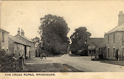
The Cross Roads, Ravensden c.1905 [Z1306/93/1/1]
Ravensden is a small village and civil parish located to the north of the Borough of Bedford. One of the ancient boundaries of the parish is the urban part of the town known as Mowsbury Park and this also acts as a buffer between the two communities.
The parish consists of pasture for cattle and sheep grazing and arable land, together with a number of ancient woods and plantations. The soil type is generally clay and there were once a number of small diggings and brickworks in the parish which together with agriculture, provided most of the employment for the local men.
Traditionally the women and girls of the parish worked at home in the Bedfordshire craft of lace making
Although the lands in the Parish were recorded as being held by Newnham Priory in the 13th century some ancient field names such as Sherevenland, Hangevehill, Upmanneslade and Wowehalvacre, suggest a much earlier settlement.
The Parish was enclosed under an Act passed in 1809.
The village feast was held on the Glebe land on 12th November each year and there was also the distribution of bread (later coal) to the poor on St. Thomas’s Day, 21st December and St. Anne’s Day 26th July, by the Agnes Martin Charity founded in 1565.
A village poorhouse (small workhouse) existed, thought to have been the building where the Case is Altered Public House was later opened. This poorhouse was closed when the Bedford Poor Law Union was formed in 1835. The three cottages at that time owned by the charity were thereafter restricted for village families who had come upon hard times. Finally, in the late 1950’s, these three (on the south side of Church End between Church Cottage and April Cottage) were sold. The income from the disposal was added to the Ravensden Town and Poor Estate Charity which still exists as an educational and grant aiding charity.
It is thought that the name Ravensden originated simply from ‘’place of the Ravens,’’ however more recently some historians have suggested that it could have come into use when a group of Danes moving inland from their stronghold at Tempsford, decided to settle on the strategic high ground where now stands the Church, giving them a wide view over the valley and towards the river. The Raven was important to the Danish or Norse culture – hence an alternative possible explanation for the parish name.
The largest part of the village, known as Church End is on the high ground in the south east of the parish, clustered around the ancient church, but other areas of habitation exist in Wood End, Cleat Hill and Oldways Road. A large new housing estate known as Woodlands Park has recently been completed. It is actually located within the ecclesiastical parish of Ravensden but for civil and public administration purposes this was transferred by the Boundary Commission into the Borough of Bedford.
In Oldways Road still stands a Free Baptist Chapel established by the Bedford evangelist and former Curate of Colmworth, the Rev. Timothy Matthews. This has though recently become a private residence.
The main road Bedford to Kimbolton (B660), cuts through the village past two notable features, the large white water tower and a delightful house known as The Grange together with Grange Farm next door and the row of cottages once occupied by workers on the farm.
This Grange was constructed with direct access to the road when the Bedford to Kimbolton Road became a turnpike road and the house replaced an earlier Grange which stood behind Great Wood and Little Wood on the opposite side of the road.
On the road to Thurleigh can be found Ravensden House and Brook Farm.
In 1863 James Howard, agriculturist, industrialist and Member of Parliament for Bedford established part of his model farm on some of the hilly strong land in the Parish, still known as Highfields, where he experimented with steam cultivation and trialled other new farming and stock breeding methods.
The modern Primary School serving the village and adjacent area is located in Vicarage Close, behind the Church.
There were formerly three Public Houses, the Old White Horse and the Blacksmiths Arms both at Ravensden Cross Roads on the B660, the Case Is Altered on Church Hill and the former and new Horse and Jockey, next door to the Church. Only the Horse and Jockey remains in use as a hostelry. (More information can be found about these in the Licensed Premises section of this site).
Two main streams flow through the village and then into the River Great Ouse
To the south of the parish is another area of high ground known as Mowsbury or Morinsbury Hill on which once stood an ancient hill fort or earthwork, followed by a large moated Norman timber house, often referred to as a castle. The site is now a nature reserve propagating various varieties of old English apples.