Yelden Castle
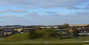
The castle from the south, February 2014
Volume III of The Victoria County History for Bedfordshire was published in 1912. It has a short article on the barony and castle of Yelden. The Trelly or Trailly family held Yelden in 1086 from overlord Geoffrey de Montbray, Bishop of Coutances, a friend of William I who had fought with him at the Battle of Hastings. There is some doubt about whether the Traillys holdings ever amounted to a barony but they included lands in Yelden, Chellington, Hinwick, Roxton, Turvey, Holcot, Biddenham, Northill and Southill. The castle, their powerbase, stands on the south bank of the River Til in the east of the parish. The typical mound and enclosure (motte and bailey respectively) had walls encircling them and a tower on the mound or motte. An inquisition of 1361 makes no mention of the castle merely saying that the manor house was in ruins, so by that date clearly the castle was no longer functioning as such.
A fuller version of the following description can be found on-line on the Heritage Gateway website. Yielden Castle is one of the most complete examples in the county. The motte, or mound is towards the middle of the eastern part of the castle and has two distinct baileys one to the north and one to the west. The oval motte is large, about 55 metres wide by 70 metres long around the base and 18 metres by 40 metres at the top. It rises in two stages from the south, the first stage forming a D-shaped platform about 5.5 metres above the level of the western bailey. Access to this stage was provided by an earthen ramp on the western side of the motte. To the north, the motte rises by about 2 metres. The summit is flat and about 1o metres square, surrounded by a low bank.
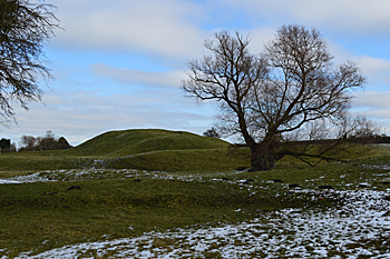
The motte seen from the bailey, February 2014
Excavations on the motte in 1882 revealed the robbed-out foundations of a substantial stone keep or tower. The eastern side of the motte descends into a broad ditch which continues around the bailey on the western side of the motte. This ditch varies between 15 and 25 metres wide and averages 1.5 metres deep.
The bailey was originally enclosed by a continuous bank, which now survives to a height of 1.5 to 2 metres along the southern and south eastern arms, and as a slight earthwork elsewhere. The northern section probably supported a timber palisade. Excavations in the bailey in 1881 exposed stone from demolished structures and uncovered foundations of a retaining wall on the inside of the rampart. Associated with this wall, in the south west corner of the bailey, lay the base of a large circular structure, which was considered to be a bastion, or fortified tower.
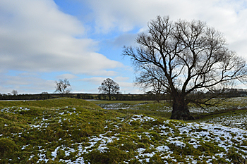
The castle bailey, February 2014
The second bailey lies to the north west of the motte, separated by the northern arm of the ditch, and is thought to belong to a slightly later phase in the development of the castle. The bailey area is roughly triangular, with maximum dimensions of about 110 metres east to west and 70 metres north to south. A further high bank or rampart, measuring up to 14 metres across and 2 metres high, skirts the north eastern and western sides of this bailey. This is accompanied on the north-eastern side by a large ditch, 10 metres across. The eastern end of the ditch joins the earlier ditch near the motte.
A dry depression is located in the northern corner of the bailey. This feature measures 25 metres by 8 metres and is thought to represent a small fishpond.
The western ditch is thought to have been formed from the original course of the River Til but has been considerably altered in both medieval and modern times. The earlier changes, contemporary with the occupation of the site, include a widening of the southern part to form a large fishpond, adjacent to the western bailey. A small mound or island located near the dam at the southern end of the pond was investigated in 1882, and found to retain the stone foundations of a medieval dovecote. A tithe map of 1842 [ref: MAT54] shows the River Til to have been diverted away from the western ditch and pond, and lying between the eastern bank and the edge of the High Street. However, this channel was infilled around 1950, and a new course dug along the former route within the base of the fishpond and the west side of the northern bailey ditch.
The development of the site from early military to later manorial use is illustrated by an arrangement of six rectangular paddocks aligned along the eastern side of the castle.