Mogerhanger Before 1086
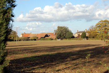
Willowhill Farm October 2009
The Heritage Environment Record [HER], formerly kept by Bedfordshire County Council and now separately by Central Bedfordshire, Luton Borough and Bedford Borough Councils is an invaluable tool for those wishing to study the landscape and built landscape of the county. The record is available on-line.
It seems reasonable that at this time the rivers of Britain would have served as major trade and migration routes in prehistory. Thus, the idea of at least semi-permanent settlements along its banks seems likely. However, no evidence of Palaeolithic, Mesolithic or Neolithic activity has so far been found in Mogerhanger.
Bronze Age
The Bronze Age, as the name suggests, was the era in which metal working was gradually introduced, though stone tools continued to be used alongside them. The earliest datable prehistoric evidence for Mogerhanger belongs to this era. A common Bronze Age feature, identifiable from cropmarks, is the ring ditch. As the name suggests this is a circular, semi-circular or oblong ditch and cropmarks of one such have been noted north of Bedford Road and east of the track leading to Willowhill Farm [HER 14031]. Several ring ditches have also been identified near the old railway line in the north-west of the parish, north of Barford Road and south of the River Great Ouse [HER 7810]. An armlet from this era was found at Willowhill Farm, scene of later settlement [HER 15989].
Iron Age
An area of extensive cropmarks has been identified north of Bedford Road and east of Willowhill Farm [HER 609]. There are indications of trackways and rectangular enclosures, perhaps Iron Age field systems.
General Prehistoric Features
A number of cropmarks in the parish suggest prehistoric origins but, without associated finds, cannot be definitely dated. These include the following:
- Cropmarks indicating the site of an enclosure east of The Ridgeway near the BusinessPark [HER 1644];
- A complex area of cropmarks which may represent enclosures and linear features north of Bedford Road and west of Blunham Road [HER 2665];
- Cropmarks east of Blunham Road and west of The Ridgeway [HER 9790];
- Cropmarks north of Willowhill Farm which show evidence of a scatter of small enclosures and linear features [HER 13973];
- A linear feature showing as a cropmark north of Bedford Road and east of the track leading to Willowhill farm [HER 14031];
- Cropmarks of rectangular enclosures south of ParkHospital [HER 15092];
- A cropmark of a fairly large enclosure composed of straight and curved lines attached to a number of features including a trackway with a double ditch to either side, just south-east of the moats south of Bedford Road [HER 16771];
- A rectilinear cropmark north-west of Bridge Farm [HER 17125]
Romano-British
A number of finds from the era of Roman occupation [43-410AD] have been found in the parish. Most impressive of these is a complex of linear cropmarks at Willowhill Farm. The area was known as Lime Hill in the 18th century and in 1860 workmen digging drainage ditches found Roman pottery, two quern stones, for grinding corn, a burial and a coin then identified as of the Gallic usurper Magnentius [350-353AD]. The pottery included high status Samian ware as well as more everyday items. A metal detectorist found a fragment of a Roman bracelet in the same area in 1989 [HER 1860]. This has led to the suggestion that there was a Roman settlement here. It is also thought that the Iron Age features from nearby noted above [HER 609] extended into the Roman period.
Four Roman and two Medieval coins were found in the parish [HER 15988]. One of the coins, from the reign if Vespasian, could be dated to AD77/78. The other coins were from the reigns of Claudius II Gothicus (268-270) and Magnentius (350-353) with one unidentified 3rd century coin. A Roman belt fitting and two brooches have also been found [HER 16191]. In 1862 a Mr. Monkhouse presented a large bronze coin (presumably a sestertius) from the reign of Commodus [180-192] to Captain Polhill Turner - the coin having been found on the railway line in the north-west of the parish [HER 7193].
Post Roman and Pre-Conquest
It seems likely that at least part of the site of the modern village of Mogerhanger was occupied for at least part of the period 410-1066AD. An Anglo-Saxon cremation in an urn, dating to the 6th century, was found in 1934 in the loop formed by Park Road, Saint John's Road and Bedford Road [HER 423]