Prehistoric Clapham
The Bedfordshire Historic Environment Record [HER] contains information on the county’s historic buildings and landscapes and summaries of each entry can now be found online as part of the Heritage Gateway website.
The earliest evidence for human activity in Clapham comes from the Old Stone Age. Two Palaeolithic handaxes were found at different dates. One came from an unknown site [HER607] whilst the other came from The Folly and is now in the Natural History Museum, London [HER 610]. The Middle Stone Age is represented by finds from Ursula Taylor Lower School when the site was excavated in 1987 prior to development work. Three pits contained Mesolithic stone flakes [HER 15607]. An incomplete stone hammerhead from the Bronze Age was found in 1921 [HER 6744].

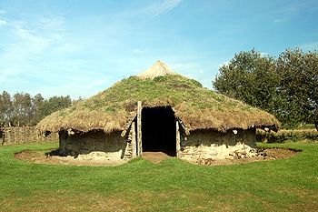
A reconstruction of a Bronze Age round house at Flag Fen October 2011
No finds from the Neolithic have been identified, other than some flints from Church farm [HER 16471], but a large number of features which may be prehistoric have been found in the landscape. Without excavation or field-walking for finds it is impossible to ascribe a more specific date other than to suggest they are prehistoric. The main evidence is from cropmarks - marks in crops which suggest buried ditches or walls, which make crops above them grow unevenly compared to the crops around them. The sites are:
- A cropmark representing a D-shaped enclosure on a north-facing spur of land, north of Outfields Farm [HER 2788];
- Cropmarks suggesting a trackway south of Yarl’s Wood [HER 3310];
- linear cropmarks west of Clapham Park Wood, though these may be natural or or later ploughmarks [HER 4483];
- prehistoric flint artefacts found by field-walking at Church Farm [HER 16153];
- a cropmark representing a large rectangular enclosure with possible internal features south-east of Judge’s Spinney; the area was field-walked in 2003 and flints were found [HER 16562]
- cropmarks or roughly parallel straight features, which proved to be ditches of a trackway on excavation, and a nearby curved feature west of Clapham Hospital [HER 16563];
- a cropmark representing an oval enclosure south of Narlyoak, The Baulk [HER 16586];
- A small, irregular cropmark south-east of College Farm [HER 16598];
- A scatter of irregular enclosure cropmarks south-east of Fairfield Farm [HER 16600]
- a cropmark representing a small triangular cropmark north of College farm [HER 16601];
- A small, sub-circular cropmark representing an enclosure on a ridge-top south of Outfields Farm [HER 16603]
- a group of irregular cropmarks east of Oakley Little Wood [HER 16605];
- a sub-rectangular enclosure respresented by cropmarks north-east of Oakley Little Wood [HER 16606];
- a group of rectangular enclosures represented by cropmarks south of Yarl’s Wood [HER 16608].