Billington Maps
The following maps are only a selection of those held at Bedfordshire Archives. To see larger images of the following maps please click on the relevant thumbnail.
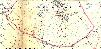
Inclosure Map
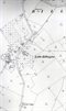
The map below is the main settled area of Billington shown on the inclosure map of 1848 [ref: MAT79/4].
Ordnance Survey Maps - Great Billington
The maps below show Great Billington on 25 inches to the mile scale Ordnance Survey maps of the 1st (1880), 2nd (1901) and 3rd (1926) editions.
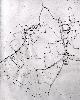
Great Billington in 1880

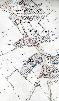
Great Billington in 1901
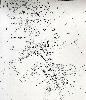
Great Billington in 1926
Ordnance Survey Maps - Little Billington
The maps below show Little Billington on 25 inches to the mile scale Ordnance Survey maps of the 1st (1880), 2nd (1901) and 3rd (1926) editions.

Little Billington in 1880
Little Billington in 1901

Little Billington in 1926
Field Names Maps
The maps below are the 1925 edition Ordnance Survey 6 inches to the mile map strips showing Billington. The have been annotated by George Herbert Fowler, the first County Archivist (1913-1940) with field names. The pink lines show the modern parish boundaries

Field names in Billington - north
Field names in Billington - central and south