The Community of Sheep Lane in General
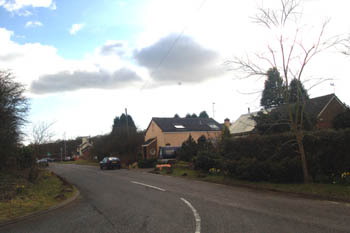
Sheep Lane looking south March 2008
Landscape
The solid, or underlying, geology beneath Sheep Lane is a type of claystone called Woburn Sands Formation. This sedimentary rock was laid down between 99 and 121 million years ago in the warm, shallow seas of the Cretaceous Period. The soil above it is a glacial deposit known as till – a diamicton laid down at the end of the last Ice Age
By Bedfordshire standards Sheep Lane is quite a high settlement. The junction of Sheep Lane with the road to Potsgrove village stands at 475 feet above sea-level. The Flying Fox stands at 435 feet
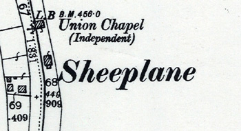
Sheep Lane or Sheeplane on a map of 1901
Name
The name, Sheep Lane or Sheeplane, is obvious and comes from the road from Woburn to the A5. It derives from being a road used by drovers. These men drove sheep down Watling Street (the modern A5) from Wales to London. Some of the sheep were driven to market in Woburn giving the road its name.
![The view towards the Fox and Hounds about 1930 [Z50/90/112]](/CommunityHistories/SheepLane/SheepLaneImages/The view towards the Fox and Hounds about 1930 [Z5_349x166.JPG)
The view towards the Fox and Hounds about 1930 [Z50/90/112]
Administrative History
Sheep Lane was always a hamlet of the ancient parish of Potsgrove and lay in the Manshead Hundred. In the 19th century it was a much larger settlement, indeed larger than the village of Potsgrove itself, as maps show. The Great Agricultural Depression of 1873 to 1896 resulted in many families leaving the countryside to find work in nearby towns such as Leighton Buzzard and Dunstable and Sheep lane never recovered, continuing to lose population through the 20th century.