Salford Before 1086
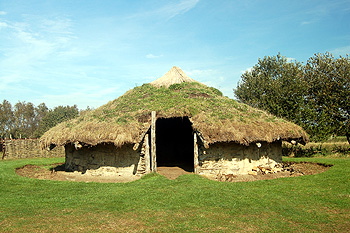
A reconstruction of an Bronze Age round house at Flag Fen October 2011
The Bedfordshire Historic Environment Record [HER] contains information on the county's historic buildings and landscapes and summaries of each entry can now be found online as part of the Heritage Gateway website.
Salford has a number of areas associated with prehistory through into the Roman and later Anglo-Saxon periods. One set of prehistoric features lie south of Salford Wood not far from a modern quarry [HER 15146]. The entry reads: "The site at Salford Quarry is located on the top of a prominent rise in the landscape and has been the subject of a number of different archaeological investigations".
"Small scale excavations in 1989 produced evidence for late Neolithic pits, and shallow Bronze Age pits. The Iron Age evidence was of four hearths, post holes and at least two hut circles. One of the ring ditches known to be on the site proved to be of a Bronze Age date and included a central cairn which had been mainly destroyed by ploughing".
"In the 1990's a large scale excavation took place at Salford as well as a geophysical survey. These excavations produced Neolithic material from a few pits but mainly from tree bole holes which is thought to indicate tree clearing in the areas, and appears to be the earliest phase of activity on the site".
"The Bronze Age phase of occupation at the site was seen via four ring ditches of middle to late Bronze Age date. They are thought to all be burial monuments although only one showed evidence for a central burial. The Late Bronze Age period produced two post hole round houses, a drip gully round house, a post built droveway and a palisade".
"The main period of activity on the site was during the Iron Age with evidence for sixteen roundhouses, at least eighteen four post and several two post structures. Two of the houses had adjacent enclosures. A droveway was defined by parallel ditches that ran from west to east across the site. The Bronze Age palisade is thought to have survived into the Iron Age. During the late Iron Age the evidence was limited to four cremation deposits located within the area of the droveway, suggesting it was no longer in use by the 1st century BC. The cremations were urned and accompanied by an accessory vessel, the cremations were dated by the brooches found with them".
"The site produced a little evidence for the Roman and Post Roman period. This was seen in a rectangular structure to the east of the round houses. A well and a number of pit-like features were dated through pottery to the Saxon period"
Two other areas lie a little way west, close together and in the area of modern gravel extraction. Their proximity suggests they were two parts of the same site. Cropmarks north-west of Whitsundoles Farm [HER 7721]were investigated between 1995 and 2005 in advance of quarrying. The site lies on the border with Buckinghamshire, and just over the border in that county a Roman field system was recorded in 1978. Some of the activity on this site is thought to relate to the later Buckinghamshire site.
The HER entry continues: "The archaeological work included a geophysical survey and trial trenching as well as an open area excavation. It found evidence for early Bronze Age activity in the form of two pits containing datable pottery, which lay close to the site of a contemporary burial mound investigated in 1990. The early Iron Age activity included scattered pits and post holes as well as boundary ditches and a well or water pit containing waterlogged timber. Later Iron Age features also included pits, and another water pit or well was found. From the late Iron Age into the Roman period a field system and trackway was identified".
"A small amount of Saxon activity was found, consisting of two sunken featured buildings and a post-built building. Evidence for medieval field systems was also found, corresponding to boundaries indicated on an estate map of 1596. Post medieval or modern quarrying had caused disturbance to some areas of the site".
The second area of prehistoric settlement in the area of gavel extraction lies north of Whitsundoles Farm [HER 16477]. The entry reads: "there is an area approximately two hundred metres by one hundred and fifty metres which shows regular square and rectangular cropmarks, they are probably evidence of agricultural or quarrying activity. When gravel extraction occurred on the site they located a high concentration of remains which dated from the early Bronze Age to the post medieval period".
"The features contained two pits with Bronze Age pottery that were located three hundred metres west of a ring ditch. A scatter of small pits and postholes, some containing Iron Age pottery was spread over an area of 1.5 hectares, of these one arrangement of post holes was suggestive of a four post structure. Generally the evidence suggests that it is the site of an unenclosed settlement. To the east of the settlement a boundary ditch with Iron Age pottery was found to cut some of the pits".
"Part of a previously unknown Saxon settlement was identified which comprised of two sunken features buildings and at least one post built structure".
Further cropmarks south of Whitsundoles Farm [HER 14837] comprise a square enclosure with linear features leading to other enclosures to the north of a west flowing stream [HER 14837]. They are most likely prehistoric.
Finally, part of the upper stone of a Roman quern, of Hertfordshire conglomerate, also known as puddingstone, was found in Salford at an unknown date [HER 1435].
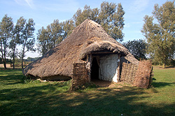 A reconstruction of an Iron Age round house at Flag Fen October 2011