The Parish of Marston Moretaine in General
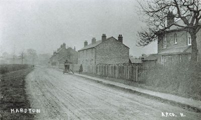
Marston Moretaine c.1900 [Z50/76/12]
Landscape
The Victoria County History [VCH] for Bedfordshire states that the greatest part of the parish of Marston Moretaine is below 200 feet above sea level, only reaching 130 feet in the extreme east. Marston village is on level ground 136 feet above sea level with land to the north-west rising to 340 feet. The village is located north of the church on the road from Kempston to Husborne Crawley. The principal buildings in 1912, when the VCH was compiled, are listed as being the church, schools and the Baptist and Wesleyan chapels. The disturbed ground to the south of the church indicates that this may have been the site of the former village. A tributary of the Ouse flows through the parish. The soil and subsoil are both clay.
According to the VCH Marston Moretaine is one of the larger parishes in Bedfordshire comprising a total of 4,290 acres made up of 1,619¼ acres of arable, 2,185½ of permanent grass and 144¼ of woods. In Kelly’s 1924 directory these figures are given as 4,286 acres of land and 4 acres of water. Marston Thrift, in the north-west of the parish, comprises about 12 acres of woodland.
There were numerous farms in the area, some of them marking the sites of ancient manors. Farm names listed in the Kelly’s directory for 1924 include Beancroft, Broadmoor, Charity, Drapers, Marston Park, Roxhill Manor, South Pillinge and Walnut Tree (Upper Shelton). At this time the Duke of Bedford was Lord of the Manor and the chief landowner. The main crops in 1912 were wheat, barley and beans. Drinking water at that time came from surface wells.
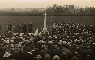
Dedication of war memorial, 1921 [Z1306/76/2]
Name
The name Marston Moretaine has changed and evolved over time. The VCH records it as Mercstun in the 10th century, Merstone in the 11th, Mershtone in the 14th and Merstone Morteyne in the 15th. The derivaton of the name is Anglo-Saxon, meaning farm (or settlement) on the marsh. The suffix Mortaine comes from the Morteyn family, who held Marston Manor in the 13th and 14th centuries. It is likely that the family originally came from Mortain in Normandy.
Bedfordshire Archives catalogue descriptions will record the name as listed on the document and be indexed using ‘Marston Moretaine’, the name used by the civil parish. The ecclesiatical parish uses the name ‘Marston Morteyne’, as does the school.
The Village Hall, October 2014
Administrative History
Marston Moretaine is an ancient parish in the Redbornstoke Hundred. Historically the parish has contained a number of hamlets and settlements: Caulcott, Lower Shelton, Upper Shelton and Wootton Green to the north, Roxhill [Wroxhill] and Wood End to the west, Marston Pillinge on the east and Heydon Hill to the south. The ecclesiastical and civil parish now includes Caulcott, Shelton and Wood End as hamlets.
From 1891 Marston Moretaine was administered by Ampthill Rural District Council; following the reorganisation of local government in 1974 it was included in the Mid Bedfordshire Council area, and since 2009 it has been part of Central Bedfordshire unitary authority. For judicial purposes it was included in the Ampthill Petty Sessional Division, and following the introduction of the New Poor Law in 1834 it was one of the parishes which made up the Ampthill Poor Law Union. At the time of writing (2020) it is part of the Mid Bedfordshire parliamentary constituency.
The parish had charities for the apprenticing of boys and for the distribution of food and clothing to the poor, amounting to approximately £63 a year in 1924.
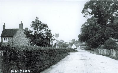
Marston Moretaine 1922 [Z50/76/13]
Population
In 1912 the VCH states that the population was scattered with only a small proportion in Marston Moretaine and the rest in surrounding hamlets. The census returns from 1801 onwards give the following population figures (no census was taken in 1941 due to the Second World War).
|
1801:
|
709
|
|
1811:
|
782
|
|
1821:
|
899
|
|
1831:
|
1007
|
|
1841:
|
1147
|
|
1851:
|
1183
|
|
1861
|
1270
|
|
1871:
|
1219
|
|
1881:
|
1179
|
|
1891:
|
1047
|
|
1901:
|
973
|
|
1911:
|
1025
|
|
1921:
|
988
|
|
1931:
|
1064
|
|
1951:
|
1836
|
|
1961:
|
1928
|
|
1971:
|
2235
|
|
1981:
|
2710
|
|
1991:
|
2605
|
|
2001:
|
3681
|
|
2011:
|
4556
|
