The Moats of Cranfield
This page was contributed by Sally Williams
Moats are not exclusive to castles and other large houses. Many farmsteads in the mediaeval period also had a water filled feature described as a Homestead Moat. These are classified as Class F earthworks and consisted an area of land enclosed to form an artificial island surrounded by water filled ditches.
The exact purpose of these moats is not clear. Many ideas have been put forward, such as for defence, drainage, waste disposal, keeping fish or to act as a cattle compound. However, the most likely reason for moats is that they were merely a fashion of the 12th and 13th centuries; they may partly be the medieval equivalent of “keeping up with the Jones'.”
Cranfield has a number of Homestead moats where there remains evidence on the ground: Wood End [Heritage Environment Record (HER) 2592], East End Farm [HER 3894], Moat Farm [HER 49], Boxhedge Farm (possibly two moats) [HER 42 and 2810], Perry Hill Farm [HER 3446], Hillgreen Farm possibly two moats) [HER 48 and 2529], Eyreswood Farm [HER 3387] and Broad Green Farm.
Cranfield's moated farmsteads, and possibly much of the settlement at Bourne and Wharley Ends, represent a period of settlement expansion and dispersion from the late 11th century until c.1300. Overall, the moats varied in ditch size, shape and in the area enclosed as illustrated in diagram 1 below:
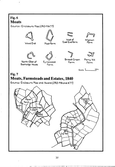
Diagram 1: sketch of homestead moats at 6 locations. Taken from Bedfordshire Parish Surveys: Historic Landscape and Archaeology volume No. 5, Cranfield (ISBN 0 907041 68 X)
The settlement at Wood End in the south of the parish dates from before 1244; perhaps Alanum de Wodende occupied the triangular moat south west of the present Wood End Farm. This moat lay on top of the ridge which extends south from the plateau and is the highest point of the parish outside the plateau.
A similar position on top of a substantial spur was occupied by the moat at Eyreswood Farm in the north of the parish. That at Hillgreen Farm was also on higher ground.
Others were in flattish locations, as at Perry Hill Farm, Moat Farm, Broad Green Farm and west of East End Farm. The latter is now under Bowling Green Road.
Those at Wood End and Perry Hill Farm have been completely filled in and only parts of those at Eyreswood Farm and Hillgreen Farm survive.
More of those at Ivy Hall Farm [HER 43] and Broad Green Farm survive, but the best remaining examples are at Moat Farm, the largest in the parish, and the roughly pentagonal shaped moat north east of Boxhedge House.
Some moats may also have disappeared before the 19th century and, therefore, were never mapped. The large ponds adjoining some of the other isolated farmsteads in the parish in 1840 may even have been the remnants of former moats.
The Enclosures Map of 1840 [reference MA77] shows a number of other probable moats at Wharley End [HER 10103], Wharley End Farm [HER 3386] Conns Farm [HER 10100], Gossard’s Green [HER 5134 and 3274 – near Moat Yard Close, Bourne End Farm [HER 3896], and adjacent to the High Street [HER 3895]