Cranfield's Greens
This page was written by Sally Williams
The main village focused on the church and a small, roughly triangular green adjoining the ovoid shaped churchyard. Only small parts of the green survive today, the remainder having been encroached upon during the post -medieval period by two groups of buildings.
Immediately east of the church was a small green that served as the focus for the cottages that comprised Tartlett End. This green has also been encroached upon; 19 -23 Court Road stand on part of its former eastern side.
The other greens which existed in Cranfield parish were all probably of 12th or 13th century origins and associated with the assarting movement. They lay in a series to the north of the main settlement, usually occurring at the junction of three or more tracks and attracting settlement along their edges. Such greens provided a communal open space and would have been used for communal activities and, in particular, for grazing. Such grazing rights were carefully 'stinted' or regulated.

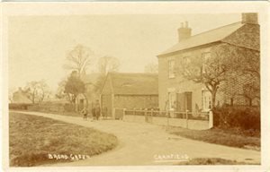
Broad Green c.1910 [ref: Z1306/34/2/18]
By far the largest of Cranfield's greens was Broad Green, a portion of which survives today as a recreation ground. Settlement developed along its northern edge and encroached on its north western corner. This settlement included the Leathern Bottle public house which was trading at the beginning of the 19th century but soon closed. It was relicensed in 1869, but again closed at about the end of the century. However, in November 1936 a newly built Leathern Bottle, the present building, was opened adjoining the former premises from which the licence had been transferred.
East of the southern end of Broad Green a widening of the road was another focus for settlement, part of East End. This included the present East End Farm and, opposite, the Baptist Chapel. The other part of East End lay just to the north east around a small triangular green, now the junction of Crane Way and Bedford Road.
North of Broad Green a narrow linear green adjoined Manor Farm, Gossards Green. For a time in the post-medieval period a Quaker meeting house stood at its north western end adjoining Meeting House Close. It was closed in 1849 and demolished in c.1866 after being used as a cottage. A burial ground, in which about 17 adults and several children are buried, adjoins the site of the meeting house. The last burial was in c.1860. The Quakers had been particularly strong in Cranfield from the mid-17th century onwards.
In the northern part of the parish at Bourne End were two more greens, Bourne End Green and Tongues Green. The latter was the focus for several cottages and larger farmsteads, including Washingleys Manor House and Hillgreen Farm. Jefferys' 1765 map of Bedfordshire depicts another building as the most impressive here: Bournend House belonging to the Baker and Coleman families in the 18th century was described as a Mansion House. It stood on the north eastern side of the green, but was demolished before 1827, probably after Mary Coleman died in 1796.