The Mills of Cranfield
This page was written by Sally Williams
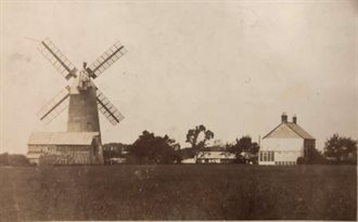
Broad Green Mill and Mill House, early 20th century [ref: Z251/29]
The high elevation of Cranfield makes it an ideal location for windmills. There is good detail in documents to support the existence of windmills at Broad Green, Cranfield Manor and Gossards Green. There are suggestions of at least two or three other mills from documents and farm and field names.
Cranfield Manor Windmill
There is not much information about the first windmill in Cranfield but it would have belonged to the Grange Farm of Cranfield Manor, owned by Ramsey Abbey.
Several references to windmills occur in the Ramsey Abbey Cartulary in relation to Cranfield. A twelfth century entry mentions a mill (vol.I, p.73) which is later more closely defined as a windmill (molendinum ad ventum) in the early 13th century (vol.II, p.22) when a miller is also mentioned (vol.II, p.9). In another reference the more usual term for a windmill is used – molendinum ventriticum (vol.I, p.276). The location of this windmill is not indicated. [Cartularium Monasterii de Rameseia, Vols. I-III, 1884-93 (W.H. Hart and P.A. Lysons Eds.)]
The field names of the time suggest that it was located in or near to a field called Millside adjacent to the Holywell behind the modern-day school of the same name.
The Ministers Accounts for the Honour of Ampthill dated 1542 refers to “a windmill in the fields of Cranfield that has completely disappeared and has for many years been laid to the ground so that the rent of 60 shillings has not been paid.” This could be the mill referred to above.
Additionally the Accounts describe another malt mill and state that William, son of Thomas Odell senior, “has a horse mill (molend equiu) called a malte myll with appurtenances in Cranfield”. [Heritage Environment Record Number 10650]
This is thought to have been near Tartlett End, below the church and may have been the successor to the Cranfield Manor mill.
Broad Green Mill
[Heritage Environment Record Number 933]
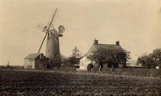
Broad Green windmill, Cranfield c.1910 [ref: Z1306/35/3/2]
There are good records for the mill at Broad Green, which was first recorded in 1693 and demolished in 1965 [ref: X278/11]. Legal documents chart its sale, mortgaging and leasing.
In 1790, the mill was clearly not in a good state when the Rector of Cranfield bought the mill for £130, but not until certain repairs had been carried out [ref; GA203]:
John Covington of Bedford, labourer, to Reverend George Davies of Cranfield. -- A windmill on Broad Green, Cranfield, after the following repairs have been carried out: To provide 1 pr. of French stones measures 4 feet 2 inches in diameter, with brasses and ironwork thereunto; 1 new shaft with wheels; a new back for the sails; to make good the lower floor; to make a second floor with stairs leading thereto; to provide conveniences for drawing up sacks of corn; to new board the roof. All within 4 calendar months. Witnesses: John Odell, John Woodcruft.
In 1791, Frances Duke of Bedford, who then held the Manor of Cranfield, rented to the Rector, as a copyhold tenant, three roods of land adjacent to the mill for 1 shilling per annum [ref: GA204].
In 1796, the Reverend George Davies sold the mill and the three roods of land to Edward Pincord of Cranfield, butcher, for £165 [ref: GA 205, 206]. Edward Pincord died in 1803 and his trustees sold the mill for £105 to Thomas Biggs miller of Marston Moretaine (quite a drop in value) [ref: GA207, 208].
In 1811, Thomas Biggs mortgaged the mill and the three roods of ground to Sarah Dennis of Bedford, spinster, for £220 [ref: GA209]. By 1827, Thomas Biggs was dead and his son, also Thomas Biggs, sold part of the lease for the mill and the three roods to John Barrett Biggs of Bromham, miller with Thomas Times of Bedford, gentleman, as trustee [ref: GA211]. Thomas and John were then joint owners and John became the miller.
There must have been some doubt about the right of Thomas Biggs to inherit because in 1826 there was a Declaration by Frances Maxey that Thomas Biggs, labourer, was the 4th child and eldest surviving son of Thomas Biggs formerly of Kempston, miller and wife Dinah (Robinson) [ref: GA 215].
In March 1836, John Barrett Biggs and Thomas Biggs sold the “Windmill on Broad Green, Cranfield, plus a messuage late in occupance Samuel Ford and a cottage and granary now in occupance Thomas Wood” to Daniel Pressland of Higham Ferrers, draper, and Richard & Joseph Goss of Lidlington, farmers at a cost of £200. [ref: GA213]
Almost immediately, Richard and Joseph Goss mortgaged their share of the mill and the three roods of land to James Stock and Jeremiah Chessum for £100 [ref: GA214].
Presumably the mortgage was never fully repaid and in 1838 the Gosses mortgaged their share to Miss Sarah A Burnham, and James Stock and Jeremiah Chessum mortgaged to Henry Lucas for a total amount of £250.
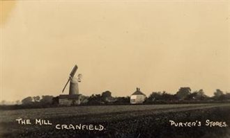
The Mill, Cranfield 1929 [ref: Z1130/34/6]
In 1839 Sarah Anne Burnham, spinster, of Newport Pagnell and Richard Goss sold the windmill, three roods of land, a messuage, cottage and granary plus three acres allotted by the Enclosure Commissioners to John Burrell Stratton of Bedford, brewer [ref; GA220]. This is the time at which the Enclosure Act came into effect in Cranfield.
In 1847 John Burrell Stratton sold the windmill and 3 roods of land to Charles Hide (or Hyde), miller, formerly of Bromham, and Joseph Joy, grocer of Bedford for the sum of £480 [ref: GA221].
In the same year, Charles Hide mortgaged the mill and the 3 roods of land plus further land at Clophill and 5 cottages to Thomas Street of Harrowden, farmer [ref: GA222]. In 1853 Charles Hide mortgaged the same package of land and property to William George Watts, and again in 1856 to George Duncombe of Marston Moretaine for £1000. [ref: GA223-224]. In 1858 a further mortgage to George Duncombe is recorded for the same parcel of land and properties for an additional £200 [ref: GA225].
In 1863, the mill was sold by George Duncombe and Charles Hide jointly to William Claridge of Leighton Buzzard, butcher [ref: GA227]. The sale took place at the Swan Inn Cranfield and at this time the mill was described as having a steam engine adjacent:
“On the Bedford to Newport Road, Cranfield. Sale of corn windmill with attached steam engine, dwelling house and 2 acres 2 roods of land, freehold and tithe free, with immediate possession. The sale is by order of the mortgagee, under his power of sale. Resident is Mr Charles Hyde. Sale at the Swan Inn, Cranfield.” [ref: SF15/18]
Claridge almost immediately mortgaged the mill with the 3 roods of land (but not the Clophill estates) to George Duncombe again.
The mill continued working until 1935 and was demolished in 1965.
Gossards Green Mill
[Heritage Environment Record Number 2530]
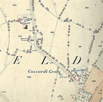
Ordnance Survey 25 inch 1st edition, 1883
The site of a windmill, built in 1848 and destroyed by fire c.1900. It is shown as a corn windmill on the Ordnance Survey First Edition. The Cassini Historical Map for 1898-1901 shows a windmill to the west of Bourne End Road, just beyond Gossards Green and before Perry Hill Farm. ['The Windmills of Bedfordshire' by J. Steele Elliott, Bedfordshire Historical Record Society, vol.xiv, p.13]
Mill at Junction of Salford Rd and Moulsoe Roads
[Heritage Environment Record Number 3186]
There is believed to have been a mill at the west end of the village that is recorded from the later 16th to the early 18th century in a number of sources:
- A sale or conveyance document from 1617, mentions an open field in which a windmill stood called 'Wyndemyll field' [ref: GA200].
- Surrender of 1764, mentions ‘a windmill and half acre in Stillipers Field’ [ref: X244/2]
- Thomas Jefferys’ map of Bedfordshire, 1765
The evidence of these documents would place the windmill in the west angle of the two roads leading off to Salford and Moulsoe, and three quarters of a mile south-west of the Church. No later record of this mill can so far be traced, and the site is not now apparent.
Windmill Farm
[Heritage Environment Record Number 3187]
The farm now called Eyreswood Farm was known as Windmill Farmhouse from at least 1840 to 1878-1883, suggesting that there was probably a windmill on the site;
The farm is shown but no mill is identified on the Cassini 1898 – 1901 map. The Victoria County History records a windmill in the vicinity which burned down "a few years ago". The present name of the farm seems to be derived from Eyres Grove or Eyreswood, a piece of woodland nearby which was recorded in 1722.
A reference from 1721 also refers to Millhill and Millhill Close in an assignment for ten years of a:
“Messuage in Cranfield built by Dr William Aspin, with the moat round it and grove of trees adjoining - Butchers Close alias Eyres (100 acres) divided and known as Horse Close, Wood Close, Calves Close, Millhill, Dry Lease, Upper Pightle, Middle Pightle, Carters Close, The Green and Millhill Close in Cranfield and Crawley, Buckinghamshire - Eyres Grove alias Eyreswood (4 acres 2 roods 19 peck) also in Cranfield” [ref: BC594]
Mill Road
[Heritage Environment Record Number 20288]
Investigations undertaken prior to a housing development in Mill Road potentially identified the site of a mill.
Trial trench evaluation on land at Mill Road, Cranfield has identified remains which broadly correspond with the results of the preceding geophysical survey. In particular, it has identified medieval plough furrows, a post-medieval field boundary and features tentatively interpreted as relating to a post-medieval windmill mound. The possible mill mound or enclosure feature was identified in Trench 1, in the form of two ditches, both of which date to the late 17th century. The interpretation of the circular anomaly as a former mill mound is consistent with the results. However, no sign of any structure or the mound itself was present, indicating that it had been severely truncated by ploughing.
[MOLA Northampton, 2015, Trial Trench Evaluation on land at Mill Road, Cranfield, 15/49 (Archaeological Report), quoted in Heritage Environment Record 20288]