Cranfield in the Anglo-Saxon Era
This page was written by Sally Williams, Derry Young, Paul and Dawn Jeffery
There has been some limited evidence in the ground of the Saxon occupation in Cranfield. The Home Farm excavations have revealed a gully, pit and possibly a pond that have been suggested as Saxon in date. There have also been some associated sherds of Saxon pottery. [HER13418]
A shard of a pottery rim from the Anglo-Saxon period was found on the Cranfield airfield site. [HER 11866]
A late Saxon find at Rings Wharley Farm is described as a copper-alloy hooked tag. The item consists of a sub-rectangular plate which narrows towards the bottom, where there is the remains of a rearward hook. There are two circular rivet holes, located a short distance
below the horizontal top side, and the edges have been decorated by means of a number of angled, parallel incisions. Such an item would have been used as a fastener for an opening in clothing for example leg bindings, purses or cuffs. [HER 19422].

Anglo-Saxon hooked tag found at Rings Wharley Farm. Image acknowledgement: Portable Antiquities Scheme Database/The Trustees of the British Museum
An incomplete copper-alloy pin, was found south of Brook Farm dating from the Middle Early-Medieval (Anglo-Saxon) period. The head is of truncated globular form, with a ring-and-dot punchmark occupying its flat upper surface and two horizontal bands of such marks below. [HER 19867]
One early-medieval silver sceat (coin) was reported as found west of Brook Farm. This is the only coin to have been reported, but it is believed that others were found nearby, with the actual total believed to have been in excess of 10 coins, all from the same area of the field. [HER 19885]
The Saxon landscape
Other evidence of the Saxon period rests in the landscape and place names. By the later Anglo -Saxon period some of the Cranfield estate boundaries, perhaps already the ecclesiastical parish boundary, had been fixed. Settlement in this area probably consisted of scattered farmsteads or hamlets.
To the south west of Wood End the boundary follows the lower part of the slope. Here the historic Salford Wood (largely cleared in recent years) lay along the south side of the boundary, just like Holcot Wood. It was a remnant of a once much larger area of woodland extending into Cranfield in the late Saxon and early medieval periods.
To the north-west the boundary, also the county boundary, closely follows natural features: a valley towards the south west and the gentle slope marking the north western limit of the plateau further north. Again the nature of the boundary here suggests it was established in an undeveloped landscape before adjoining estates and settlements had extended their cultivated land to the limits against each other. (The boundary would have followed a more angular line if it had been fixed between the arable lands of adjoining estates.) In this case it was more likely to have been fixed through woodland, possibly by the later Saxon period.
A large remnant of this early woodland, Lean Wood, survived at Wharley End until the late 17th century. This occupied at least the closes called Cartwrights Close, The Ten Acres, Wood Close, The Eight Acres, Fox Holes and Roe's Piece though now only a fragment survives as Lean Spinney. A little to the south west in Buckinghamshire a similar area of ancient woodland still survives today, Moulsoe Old Wood. This and Lean Wood were probably part of one continuous stretch of woodland before the medieval period.
The map below shows what is known of ancient woodlands in and adjacent to the parish. Much of it had been cleared by 1682 and some of the remainder by the 1960s.
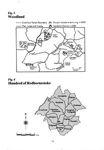
Cranfield woodland, to see a larger version, please click on the image
A portion of ancient woodland, Holcot Wood, has for many centuries occupied the north eastern corner of Hulcote (now Hulcote and Salford) parish along the south side of the boundary with Cranfield. A small area of this woodland now extends into Cranfield parish, but is only of mid-19th century origin. Saxon woodland in this south eastern part of Cranfield is indicated by the use of the place-name Wood End since the early medieval period (2).
In Cranfield the group of closes named Spinney Close, Lower Pightle, Ploughed Close and Turnip Close and the adjoining fragments of wood were once a single area of woodland called Hooks Wood; it was mostly cleared in the late 17th century
Cranfield’s largest surviving piece of historic woodland is Bottom Spinney that sits adjacent to Marston Thrift woodland on the parish boundary with Marston Moretaine.