The Parish of Cranfield in General
This page was written by Sally Williams, Derry Young, Paul and Dawn Jeffery
Landscape
Cranfield parish is dominated by a central raised plateau at about 110 metres above sea level; all around this plateau the ground drops away by varying degrees towards the parish perimeter. The most striking slopes are to the south-east between Wood End and East End where the land falls steeply for some 20 to 30 metres to the Marston Vale. However, these slopes are broken up by a number of spurs projecting eastwards.
A small area at the foot of the slope in the south-east corner of the parish has predominantly non-chalky soils developed from gravelly and loamy deposits overlying Oxford clays. On the plateau rather chalky soils have been derived from chalky boulder clay deposits. Both parish soils are heavy and imperfectly or poorly drained: numerous ponds have long been a common feature of the Cranfield landscape; several streams rise in and flow out of the parish.
The streams, which mainly issue from springs just below the plateau edge have been responsible for shaping much of the topography on which the parish area of Cranfield is based. One stream flows west from Wood End towards the River Ousel and has created a broad valley whose northern slope forms the southern part of the parish. Another stream flows eastwards from the spring at Holywell near the present village centre; to the west, where the ground slopes away very gently into Buckinghamshire, two streams flowing north and south west from Wharley End have cut their own small valleys. In the north of the parish two roughly parallel streams flowing northwards have created a prominent spur of land between them. The easternmost of the streams was known as The Bourne and has given its name to the northern part of the parish, Bourne End.
Name
The nature of the local landscape at this time may be hinted at in the name Cranfield. The first element in the name simply refers to cranes, once common birds in England, but the second element derives from 'feld'; place -names experts now believe this term to have been used by the earliest Anglo -Saxon arrivals to refer to open country, and in particular to describe the contrast between open country and an adjoining landscape feature, most usually woodland. Put more simply, feld can mean "open country within sight of trees ". In the late Roman and early Anglo-Saxon period this description presumably applied to the area that became known as Cranfield. Settlement in the Cranfield area during the Anglo-Saxon period probably consisted of scattered farmsteads or hamlets.
The Cranfield name originally did not refer to a specific settlement but to an area. It later came to be used as the name for the major landholding or estate locally, the ecclesiastical parish when it was established and, during the medieval period, for the main village which developed in that parish. That village and the other hamlets or farms were not necessarily in the same places as any of the earlier Anglo- Saxon settlements.
Administrative History
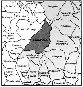
Cranfield is an ancient parish in the west of Bedfordshire, in the Redbornestoke Hundred; it comprises 1,618 hectares (3,998 acres) and is part of the Central Bedfordshire Unitary Council area. The population at 2018 stands at around 6,000. Cranfield is bordered by the Buckinghamshire parishes of North Crawley, Moulsoe and Broughton to the north and west and by the Bedfordshire parishes of Hulcote and Salford, Marston Moretaine, Wootton and Kempston Rural to the south, east and north east.
The first documentary reference to Cranfield is found in a charter of AD 969 in which King Edgar granted land at Aspley (Guise) to Aelfwold. The boundaries of this estate are described in detail and include the following section:
" along the stream. From the stream to Cranefeld dyke; from the dyke to the old charcoal pit where the three boundaries meet, of Cranefeld men, and of Mereston men, and of Holacot; from these three boundaries to the old maple tree, ".
This shows that Aspley then included the area of Hulcote; only later did Hulcote become a separate parish, though more recently it was joined with Salford. The coincidence of the Cranfield, Marston Moretaine and Hulcote boundaries at one spot occurs east of Wood End at map reference SP 9604 4055; this could well be the site of the old charcoal pit.
![Cranfield lace makers [Z1130/33/5/2]](/CommunityHistories/Cranfield/Cranfield-images/Z1130-33-5-2-lacemakers350x228.jpg)
Cranfield lace makers [Z1130/33/5/2]
Population
The Domesday Book of 1086 recorded that Cranfield contained eighteen villagers, two smallholders and five slaves – a total of tweenty-five. These were just the heads of households so to account for dependants the number probably needs to be multiplied by a factor of at least four, suggesting a total population of around one hundred people, a reasonable size for the day. The following figures are taken from censuses:
- 1801: 961;
- 1811: 1,035;
- 1821: 1,153;
- 1831: 1,260;
- 1841: 1,371;
- 1851: 1,515;
- 1861: 1,591;
- 1871: 1,529;
- 1881: 1,447;
- 1891: 1,365;
- 1901: 1,239;
- 1911: 1,199;
- 1921: 1,059;
- 1931: 1,159;
- 1951: 2,160;
- 1961: 2,501;
- 1971: 4,035;
- 1981: 4,343;
- 1991: 4,405;
- 2001: 4,905;
- 2011: 5,369.