Willington Maps
The following maps are only a selection of those held at Bedfordshire and Luton Archives and Records Service. To see a larger image, please click on the relevant thumbnail
Early Maps
![Russell estate map showing the village in 1779 [R1-75]](/CommunityHistories/Willington/WillingtonImages/Russell estate map showing the village in 1779 [R1_150x136.jpg)
Russell estate map showing the village in 1779 [R1/75]
![Tithe apportionment map for Willington of about 1840 [MAT51]](/CommunityHistories/Willington/WillingtonImages/Tithe apportionment map for Willington of about 18_119x150.jpg)
The tithe apportionment map of 1840 showing the village: note that the map is east-west rather than north-south [MAT51]
Ordnance Survey 25 Inches to the Mile Maps

The western part of the village in 1901

The western part of the village north of Bedford Road in 1926

The western part of Bedford Road in 1926
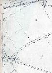
The eastern part of the village in 1901
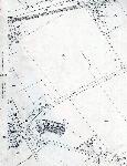
The eastern part of the village in 1926
Ordnance Survey 6 Inch maps of 1902 annotated to show field names

Field names in the northern part of the parish
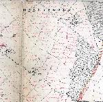 Field names in the southern part of the parish