Turnpike Farm Bolnhurst
Turnpike Farm February 2016
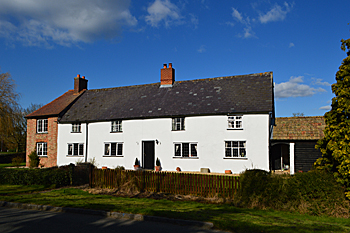
Turnpike Farmhouse was listed by the former Department of Environment in August 1983 as Grade II, of special interest. The listing dates the building to about 1700. It is built of colour-washed roughcast over a timber frame, has a slate roof and comprises two storeys. There is a 19th century red brick two storey addition to the west with an old clay tiled roof and a one storey pantiled extension to the east gable end.
The farm takes its name from the fact that the modern B660, on which its stands, was a turnpike, or toll, road created in by act of parliament in 1795, the fifteenth so created in the county. Generally the repair of a road was the responsibilityof the parish through which it went. All too often this was a duty neglected, meaning roads were difficult at any time and often impassible in winter. This situation was clearly hopeless for a nation built on trade, internal as wel las external, so in the 18th century companies were increasingly formed to manage whole stretches of road, exacting tolls from all users which were then used to maintain the road in good order. This tol lroad ran from Bedford to Kimbolton [Huntingdonshire] as the B660 still does.
In 1877 the farm, along with other property in Bedfordshire, Cambridgeshire and Huntingdonshire was for sale at the Saint Neots Corn Exchange. The particulars [X65/39/1] stated that the farm comprised 148 acres, 3 roods, 30 poles. Fields in Bolnhurst included: Home Close; Way Close; Near Ground; Flawns; Drulers; Bottom Mill Field; Top Mill Field; Great Mill Field and Cow Close. Land in Pertenhall included Little Offness and Great Offness and land in Keysoe included Spinney Field.
Up to 1912 George Sharman had been tenant of Turnpike Field, the owner being Major Duberly, but Sharman died in that year [BMB4/1/16/39]. The Rating and Valuation Act 1925 specified that every building and piece of land in the country was to be assessed to determine its rateable value. The valuer visiting the property [DV1/H22/10] found that it was owned by and occupied by Heathcote and Chandler, presumably a farming firm who had bought it from Major Duberly at some point. Rent in 1912 had been £2,000 “all in”. The farm comprised 148 acres, 1 rood, 1 pole. Some of the land was in the parish of Keysoe. A colleague of the valuer wrote in 1927: “A poor place. Beds of onions … Homestead bad – old thatched barn expensive. House fair”.
This “fair” house comprised two reception rooms, a kitchen, a dairy, a scullery and a store room and had five bedrooms upstairs. Outside was an earth closet and a coal barn. The main block of farm buildings contained: a stable; a hay and chaff barn; an implement store (“falling”); a bullock place for four beasts; a loose box; a cow place for three; two foaling boxes; two pig boxes; a corn and chaff barn and a three-bay open hovel. To the right was a hen house and to the left a cart hovel. In the stockyard was a large implement barn.