Bolnhurst in Prehistory
The Bedfordshire Historic Environment Record [HER] contains information on the county’s historic buildings and landscapes and summaries of each entry can now be found online as part of the Heritage Gateway website. Prehistoric sites in Bolnhurst are generally confined to cropmarks, which show disturbances of the soil due to ancient banks, ditches and walls. There are, however, two more precisely dated sites.
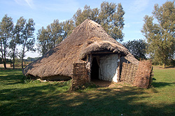
A reconstruction of an Bronze Age round house at Flag Fen October 2011
The earliest datable feature in the landscape is a fragmentary circular feature north-west of Southfields Farm which probably represents a ring ditch. These are Bronze Age in date and usually represent barrows or, perhaps, large circular huts [HER 16695].
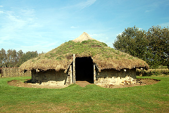
A reconstruction of an Iron Age round house at Flag Fen October 2011
An Iron Age hillfort has been identified near Manor Farm [HER 315]. It was later partly re-used as a medieval moated site, probably denoting the manor house of the Manor of Bolnhurst. The internal bank or rampart is 25 metres wide and one metre high where it survives. The enclosed area is about 110 metres east to west and the western part of the ditch is filled with water. Flints and Roman pottery have both been found in the ditch as has a Roman antoninianus, a debased silver coin dating from between 222 and 235 – the reign of the Emperor Severus Alexander.
Other sites which may, or may not, be prehistoric are as follows. In these cases field walking or excavation would be necessary to determine a more precise date span:
- A rectangular enclosure with a double ditch west of Crowhill Farm [HER 3078];
- A compact block of rectangular cropmarks north of Manor Farm [HER 13739];
- A block of three irregular cropmarks north-east of Mount Pleasant [HER 13740];
- A block of rectangular cropmarks south of Hatch End and west of Manor Farm [HER 14016];
- Two linked curved enclosure cropmarks and a roughly square cropmark south-west of Manor Farm [HER 14017];
- A small group of rectangular marks north-west of Blacklands Farm [HER 15012];
- Curved cropmarks bisected by a straight mark west of Brook Farm [HER 15013];
- A small group of irregular cropmarks east of Short Wood [HER 16668];
- Three sides of a rectangular mark south-west of Brook Farm, which may have an entrance on the west side [HER 16669];
- Two separate rentangular cropmarks north of John Bull Cottages [HER 16671];
- A small group of rectangular and irregular cropmarks east of the church [HER 16672];
- A faint mark perhaps showing a rough circle north-east of Crowhill Farm [HER 16673]. It is at the top of a spur of land between two former watercourses;
- Two curved cropmarks north of Crowhill Farm [HER 16674];
- Rectangular and polygonal cropmarks west of the Old Rectory [HER 16675];
- A group of rectangular and irregular cropmarks north-west of Greensbury Farm which are earlier than the medieval moat for the manor house of the Manor of Grymsbury [HER 16676];
- An irregular polygon cropmark south-east of Mount Pleasant [HER 16677];
- Three sides (south-west, north-west and north-east) of a rectangular enclosure north-west of Wood End [HER 16689];
- Faint cropmarks which may be a block of rectangular enclosures east of Honeysuckle Cottage [HER 16690].
- A small, isolated rectangular cropmark north of Cherry Orchard Farm [HER 16692];
- A pair of small rectangular enclosures south of Wickey farm [HER 16735].