1819 Map of Leighton Buzzard Overview
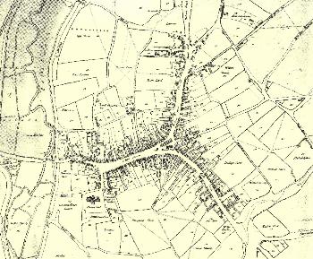
Please click on the map above to see a larger image
The map above was published in 1819 by Benjamin Bevan junior [X1/34/1]. In 1821 William Rose of Leighton Buzzard published a reference booklet to accompany the map [X1/34/2]. This booklet gave the owner and occupier of the various buildings and pieces of land on Bevan's map. To see individual areas of the town and discover who owned and occupied the buildings simply click on the appropriate link below:
North End (now Church Street)
Northern part of Woburn Street (now North Street)
Southern part of Woburn Street (now North Street)
Friday Street (later West Street)
Hockliffe Street
Market Square
High Street
Northern part of Lake Street
Southern part of Lake Street
Church Square
Lovell End and Stairs Lane (now Bridge Street and Friday Street)