The Community of Ireland and Rowney in General
133 to 136 Ireland March 2008
Landscape
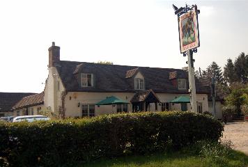
Ireland lies around 225 feet above sea level, the height at the Black Horse. Rowney Warren Wood lies between about 155 (in the south-east) and 280 (in the north-west) feet above sea level.
The solid, or underlying, geology varies. The village of Ireland, most of Old Rowney Farm and Keeper's Farm, for example, lie on a type of sandstone known as Woborn Sands Formation, laid down between 99 and 121 million years ago in the shallow seas of the Cretaceous Period. The soil here is, therefore, sandy. A thin band of mudstone called Oxford Clay Formation laid down between 154 and 164 million years ago in the Jurassic Period lies on part of the land of Old Rowney Farm where the soil is a glacial deposit of sand and gravel laid down during the mid Pleistocene Epoch. New Rowney Farm lies on a type of mudstone known as Gault Formation laid down between 99 and 112 million years ago. The soil here is glacial till.
Name
The following text was written by Margaret Roberts, Volunteer Historian, Warden Abbey Vineyard
From inland to Ireland
The placename of Ireland is rooted in the area’s monastic history, beginning in 1135 when Radulf [Ralf] Malclerc, a lesser-known Norman lord, granted a hide (120 fiscal acres) to Wardon Abbey on its foundation. The whereabouts of Malclerc’s gift only become clear thanks to an entry in the cartulary of Newnham Priory, which describes how, in 1364/65 the monks agreed to pay Newnham Priory 5 shillings cash in lieu of tithes on arable lands in Southill called ‘Malclerc’s Inland’. The Old English word inland (Middle English inlōnd) refers to a detached parcel of demesne, which was usually cultivated by the manorial lord or his steward rather than being let to tenants.
On 26 April 1526 Abbot Augustine London leased Wardon Warren and the right to take rabbits from other specified locations to Edward Peke; rent of £5 yearly plus 40 couples of rabbits were due. The location of the inland was finally pinpointed thanks to Peke’s lease, which included ‘Inlond next Rowney Warren’, from where the tenant could take the lops, brash, broom, underwood, and rabbits. ‘Indelonds pasture’ was valued at £1 for tax purposes in 1535. The abbey closed on 4 December 1537, and the 1537/38 Court of Augmentations accounts show Edward Peke paying the Crown 113s 4d in rent, which included one mark (13s 4d) in lieu of 80 rabbits at 2d apiece.
A note in the margin of the 1605 survey of the manor of Wardon mentions ‘A parcel of Land called Inlands by Estimation 80 acres’ in connection with the lease for Warden Warren. There seems, however, to be some uncertainty regarding its status. The ‘Inlands’ area remained blank on John Speed’s map of Bedfordshire (1611) and it was not mentioned in documents relating to the sale of the manor of Warden in 1629. The last known occurrence dates to 1650/51, when Owen Brett mortgaged the ‘manor or grange of Rowney’, the document noting that ‘Rowney Warren extends from Lords hill to Inland’. The placename evidently evolved from inland to Ireland between 1651 and 1765 when ‘Ireland’ appeared on a map of Bedfordshire prepared by Thomas Jefferys.
For further information, see From Monastic Inland to Ireland, Parish of Southill.
From Rounhey to Rowney
The area on the western margin of Southill, now known as Rowney, does not occur in Domesday (1086) nor
was it mentioned when Henry II issued a charter confirming the assets held by the Cistercian monks of Wardon Abbey in 1160/61. Nevertheless, it is likely that much, if not all, of the land in the very north-west corner of the parish had been under monastic control since the abbey was founded in 1135.
Radulf Malclerc gave the monks land and woodland between Greneden (Green Hill) and the Southill-Chicksands parish boundary in the mid-12th century, and it is here that the monks established a warren (well in excess of 460 acres). By 1198 the abbey had also set up an adjoining monastic farm or grange, which eventually extended to at least 555 acres of arable, pasture, and meadow (not all contiguous), and 81 acres of woodland. Old Rowney Farm [OS Grid: TL 1209 4190] is thought to occupy the site of the grange buildings and fishponds.
Between c. 1170 and c. 1200, Rounhey occurs nine times as a subject heading and twice as a marginal note in the cartulary of Wardon Abbey (the book containing copies of important documents) [BHRS, 13]. The scribe who produced a charter of Richard I in 1198 used Rueye, whereas Rueneje, first found in the cartulary c. 1180/1200, is seen more than once in the early 13th century. Other variations noted during the monks’ tenure are Runheye (Henry III grants right of free warren, 1252), Ronney (Taxatio Ecclesiastica, 1291), and Roundhey (Valor Ecclesiasticus, 1535). The earliest known occurrence of the spelling Rowney dates to 1538, when the ‘Manor of Rowney or Rowndhey’ was valued at £28 (£20 for the grange and £8 for the warren) in the Court of Augmentations accounts for financial year 1537/38 [BHRS, 63, 84 (112)].
It has been suggested that the name was derived from the Old English ‘ruhan hæge’ meaning rough enclosure. However, given the context, a spiritual interpretation may be more appropriate. The Middle English noun ‘rǒun(e’ (derived from the Old English rūn, rune) meant a secret, a mystery, or the secret counsel of God, while ‘hei(e’ referred to an enclosed plot of land.
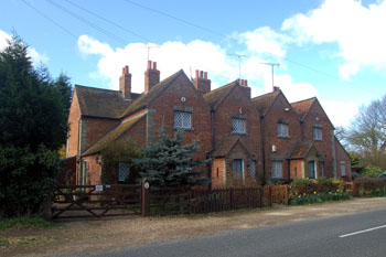
Black Horse Ireland April 2007