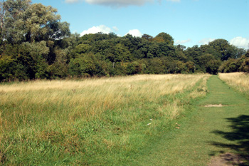
The line of trees is the bank and ditch of Wauluds Bank - September 2009
Waulud's Bank is one of the few nationally important prehistoric sites in Bedfordshire. It is a bank and ditch which surrounds the source of the River Lea, which forms its western side, at Leagrave Marsh and is usually considered to date from the late Neolithic period. The feature lies about 400 feet above sea-level and extends over some eighteen acres. It is number 820 in the Bedfordshire Historic Environment Record [HER] which simply says of it: "Possible Neolithic henge monument, certain Iron Age fortified enclosure". Waulud's Bank is a scheduled ancient monument. As the source of a river the site has obviously attracted humans for millennia, presumably from a combination of religious and the very practical reasons - a source of fresh water. A Mesolithic artefact was found on the site, pre-dating the excavation of the enclosure by thousands of years. Today the visitor would not know an important prehistoric site lay around them though, in summer especially, the paths around the river and skirting marsh and monument can feel miles from anywhere (if you close your ears to the muted roar of traffic and the sounds of the trains) rather than a few hundred yards from the Marsh Farm Estate.
The enclosure lies on chalk, capped by a deposit of gravel, forming a ridge to the east and a natural slope with a drop of some twenty five feet east to west. Five springs issue from a basin ten feet deep and a hundred feet wide at the northern end of the enclosure and these springs form the River Lea. Today the enclosure is semi-circular, the bank, much flattened but rising to eight feet at one point, lying inside the ditch. The bank is almost obliterated in some places, presumably by medieval ploughing as the marshland around the structure drained. No trace of an entrance can be found in the bank and ditch. In 1953 it was hypothesized that it may have been at the northern end where a track enters the site [but see the re-excavation of 1971 below]. The western side of the enclosure south of the Lea is now occupied by Marsh Farm, obliterating the ancient features. Interestingly, William Austin in his 1928 History of Luton records another bank outside the ditch at this point.
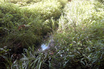
One of the Five Springs September 2009
Before World War Two Waulud's Bank was used for grazing sheep. The shepherd was a friend of the local antiquarian Worthington George Smith and collected a lot of, mostly Neolithic, flints from the site including polished axes, scrapers and arrowheads. In 1882 two crouched burials were found just south of the enclosure in a shallow pit with their heads to the east.
Much of our knowledge of the site comes from an archaeological excavation undertaken in July and August 1953 by the South Bedfordshire Archaeological Society and described by a local archaeologist of national standing, James Dyer, in Bedfordshire Archaeologist Volume 2, Number 1. The dig was undertaken when the water level in the Lea was eight feet below the surrounding land and formed a pond choked by weeds. Two sections of the bank and ditch were excavated - one on the northern side on the Sundon Road Recreation Ground and the other on the eastern side in Marsh Farm Spinney where the bank was at its highest. A single post hole was found in front of the bank at the northern end providing some evidence that the bank was held up by a revetment of wooden stakes at some point in its history. Excavators found that the builders and first users of the enclosure were pastoralists and had large numbers of oxen, judging by the finds during the dig. Considerable amount of Neolithic pottery were found along with some Roman sherds
The eastern section of the dig showed evidence of a slight step close to the top of the bank which was interpreted as a possible stockade, although no post holes were discovered. The foundations of a small hut, perhaps wattle and daub construction were found at this eastern side, extending north and excavation showed that it was in a irregular, kidney-shaped hollow two feet wide by four feet long by eight inches deep. A two feet wide area of flat chalk surrounded it and this was itself surrounded by an irregular circle of stake holes. A three feet wide entrance lay to the west. Average diameter of the hut was eight feet. The hollow produced an ox's knee joint, four small flint flakes and a broken flint blade.
James Dyer, in his article, stated that Waulud's Bank was probably built at the same time and by the same people as a three hundred foot long barrow, destroyed around 1900, on the west side of Galley Hill, a henge barrow at Barton Hill Farm, Streatley, discovered by aerial photography in 1948 and a henge at Maulden Firs, Streatley about five hundred feet in diameter discovered as a crop mark in 1962. All these features lay close to the Icknield Way, a prehistoric track way running through the county from Eaton Bray in the south-west to Shillington in the north-east. A putative date for the construction of Waulud's Bank is the beginning of the second millennium (i.e. after 2000) BC
Gold coins from the end of the Iron Age have been found in and around Leagrave Marsh. These include specimens from the reigns of Tasciovanus of the Catuvellauni (c.20 BC - 9 AD), Addedomarus of the neighbouring Trinovantes (c.15 - c.5 BC) and Cunobelin of the Catuvellauni (9 - c.40 AD). This because during the late Iron Age and into the Roman period the surrounding Leagrave Marsh was the site of a settlement, which is believed to have moved to higher ground during the Romano-British era to the area around Runfold Avenue. Two Anglo-Saxon burials were discovered in 1905 about four hundred yards west of Waulud's Bank and they were reburied in Biscot churchyard. During the early Medieval period the site was once again occupied as pottery, iron nails and other piece of metal have been found. Evidence from the excavation showed that, after the Norman Conquest of 1066 the ditch of Waulud's Bank was enlarged, perhaps in conjunction with a watermill in Leagrave.
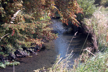
The River Lea at Wauluds Bank September 2009
The Council for British Archaeology's Group 9 Newsletter Number 2 (page 5) of 1972 has a short piece on a recent excavation of Waulud's Bank prior to construction of a dual carriageway. The article, again written by James Dyer, states: "The 1971 excavation confirmed that the whole earthwork was Neolithic in date. Its ditch, 6 feet deep and 30 feet wide was flat-bottomed. The material excavated from it had been piled up to form a bank, the front of which was revetted with turves. There were no indications of retaining posts (though one hole was found in 1953). Sealed below the bank were pieces of Windmill Hill pottery, including a lug, other decorated Neolithic sherds, a selection of flint work (including a leaf-shaped arrowhead), and many domestic and wild animal bones".
"Previous finds of many arrowheads, and the closeness of the marshes, suggests a hunting economy, supplemented by animal husbandry and agriculture. The site, with its continuous Neolithic ditch, is unique as a domestic monument. Its position beside a river resembles a number of henge-monuments, but its internal bank creates a problem. No original entrance has been found: that suggested in 1953 has since been shown to be modern [the proposed northern entrance - see above]".
"Part of the site had been utilized during the late Iron Age, perhaps in conjunction with a known, nearby open site. The majority of the site is preserved as a public open space and adventure playground. Only a small section of ditch on the southern side of the earthwork will be destroyed".