Luton in the New Stone Age

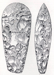
Neolithic polished axehead in William Austin's History of Luton
The New Stone Age, or Neolithic, lasted from about 4000 BC to about 2350 BC. It was preceded by the Middle Stone Age, or Mesolithic and was succeeded by the Bronze Age. At this time families began to settle in areas and farm cereal crops as well as keeping livestock. This development in places such as Mesopotamia and Egypt marks the beginnings of what is commonly thought of as civilization.
The nationally important monument known as Waulud's Bank at Leagrave Marsh is generally considered to be a Neolithic henge monument. There are possible hints of other sites of habitation in what is now Luton from this time. Local historian William Austin in Volume I of his History of Luton of 1928 (pages 14 and 15) wrote as follows: "On the long ridges of gravel from Leagrave Marsh to Luton Hoo the collector may expect to find the remains of Neolithic people. Human skeletons, bones of domestic and wild animals, burnt and unburnt bones, charred wood, and broken pottery may be found within eighteen inches of the surface. In 1914, the writer, in company with Mr. Walter Evans, of Luton, examined a kitchen-midden in the gravel pits worked by Mr. George Buckingham in New Bedford Road. Charred wood, burnt bones, the split bones of animals, and ox teeth were found there".
"In the same pit the workmen came upon the skeleton of a human being. The men had noticed that the skeleton was in a crouched position, the lower limbs drawn towards the body. The bones were extremely friable".
"There is a similar gravel-pit a little west of Mr. Buckingham's pit, at present time worked by Messrs G. Powdrill and Sons. Near the surface traces of human settlements and burials have been found. Mr. Worthington G. Smith, Mr. Frederick Gurney and the late Sir John Evans found Neolithic remains in these pits".

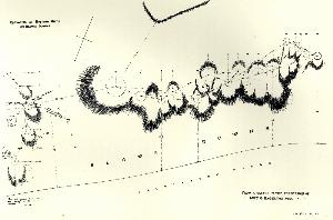
Sketch plan of Neolithic settlement on Blows Down - to see a larger image please click on the picture
"Neolithic man dwelt in wattle huts built in holes dug out on the slopes of the hills or in natural depressions on the hills. In the valleys and on the plains they built their huts in enclosed situations, protected by ramparts and stockades. Some holes - the sites of wattle huts - are to be seen on warden and Gallows Hills, Blows Down, Dunstable Downs, Totternhoe Knoll, and Barton Hills. The writer has called the attention of the Committee for the Preservation of Ancient Monuments to many of these hut-circles, and particularly to a group of twenty-four on the slope of Blows Down against the Lime-burning Works there". A diagram of the Blows Down settlement appears above. A polished stone axehead was found at Blows Down in 1893 as noted by the Bedfordhire Historic Environment Record [HER 198]
Austin goes on: "They buried their dead in long barrows, shaped like the inverted half of a pear. Such barrows have been found at the foot of Warden Hill, at Dray's Ditches, Bramingham, and Biscot, but have in recent years been obliterated by the plough. We have found no traces in Luton of Dolmens, megalithic tombs, or cists of Neolithic times". Interestingly, a supposedly Palaeolithic implement illustrated in Austin's book is now identified as a Neolithic polished axehead [see the top of the page]. It was discovered in 1913 during the digging of a trench for the Luton Water Company in Stopsley [HER 363]. A similar, though broken, axehead was discovered by Worthington George Smith on Blows Down, near Chalk Farm, in 1893. In the same year he discovered a flaked axe on a path in People's Park, brought in with other stones to make the path. Both finds are noted in Smith's Man the Primeval Savage of 1894 (pages 90, 179 and 307).
There are other discoveries, not specifically mentioned by, or coming after, William Austin's book. A Neolithic implement, described as a flat, oval axe, was found at Lully Hill, Leagrave at an unknown date [HER 191]. A Neolithic axe was dug up by a D. Willoughby just south of Brackendale Grove in 1951 and is now in Luton Museum [HER 175] and a long barrow was identified on Leagrave Common, near Waulud's Bank. This barrow, if such it was, suffered plough damage and now lies in a recreation ground, as noted by the Bedfordshire Historic Environment Record [HER 797]. The Historic Environment Record [HER15847], also records a geophysical survey carried out at Butterfield Green in the 1980s, which produced evidence for a rectilinear and possible sub-circular ditched enclosure. This was followed up by a small excavation which produced a number of flints of a Neolithic date. A limited amount of Iron Age and Roman evidence was also available and mainly comprised ditches and pits. Field walking in the 1980s produced Neolithic, as well as Mesolithic, Bronze Age and Medieval artefacts at Great Bramingham Farm [HER15224]. The Historic Environment Record [HER 15227] also records Neolithic as well as mesolithic, Bronze Age and Medieval artefacts from an area west of Bradgers Hill, found in the 1980s. In the 1990s to the north of Stopsley Sports Ground in Luton a small scatter of burnt flints, clay and flint flakes were collected [HER16076].
Allotments can be a fertile soil for ancient remains as well as fruit and veg. In 1998 Ren Hudspith carried out a sample surface survey of a number of allotments in Luton, a total of some 20 hectares. The results were published in Bedfordshire Archaeology in 2001 (page 97). Scatters of Neolithic and Bronze Age flints were discovered at the following sites (with Historic Environment Record references in square brackets):
- Stockwood Park, between London Road and Whitehill Avenue, some of these flints were fire fractured [HER17752];
- Wigmore Lane, between The Dell, Browbrook Vale and Eaton Green Road[HER17753];
- Toddington Road, off the main road between Harry Scott Court and the railway line [HER17754];
- Limbury, between Birdsfoot Lane, Riddy Lane and Truro Gardens [HER17755];
- Limbury, south of Riddy Lane [HER17756]
- Round Green, off Stockingstone Road [HER17757];
- Lewsey Farm, off Ravenhill Way [HER17758];
- Wigmore Valley Park, off Wigmore Lane [HER17760];
- New Bedford Road [HER17761]
Lynchets are banks of earth which form on the downslopes of hills when the area has been ploughed for any period of time. They form as disturbed soil falls down the incline. They are also called strip lynchets. Where such features survive, especially on fairly marginal land, they are often ascribed to the Neolithic, as crop farming began at that time, though often without any archaeological evidence. An old alternative name for these lynchets is Celtic Fields. There are a number of areas of lynchets around Luton ascribed, rightly or wrongly, to the Neolithic. The following have been identified by the Bedfordshire Historic Environment Record:
- Winsdon Hill [HER 187];
- People's Park [HER 208];
- Bradgers Hill [HER 209];
- the west side of Farley Hill [HER 210];
- Buxton Hill [HER 211];
- Hart Hill [HER 366];
- between Runley Road and Long Croft Road [HER 2597];
- Brendon Avenue and Falconers Road [now built over] [HER 12369]