The Public Well House Whipsnade

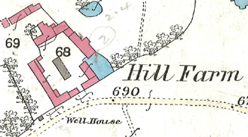
The site of the well house in 1880
The Whipsnade Vestry minutes of 4th June 1857 state: "The parish well is situated on the green adjoining the southern boundary wall of the stackground of the hill farm and about 60 yards to the north of the rectory garden. It was commenced in the year 1844 and remained unfinished for want of funds until the year 1856" [ref: P87/8/1].
In 1933 Bedfordshire Historical Record Society published Volume II of its Survey of Ancient Buildings. J. Steele Elliott wrote about wells in the county. For Whipsnade he noted: "The so-called Manor of Woodmanley [a spurious manor] in 1629 included a pightle called Blackwell. Pipeswell Plantation and Sallowspring Wood are shown on the 6 inch Ordnance Survey [map]. The community well-house and pump stand on the north of the Church at the 700 foot contour. The well is similar to the one at Studham, and is said to be 290 feet in depth. The boring for the well at the Zoological Gardens is over 500 feet deep, the supply being apparently inexhaustible".
The well house is shown on a map of 1960 but is not shown on a map of 1972 and so, presumably, was filled in during that twelve year period.