The Parish of Stagsden in General
Landscape
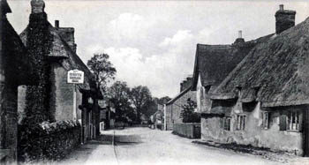
The High Street about 1920 [X291/198/33]
Volume III of The Victoria County History for Bedfordshire, published in 1912 gave the size of the parish as 3,419 acres. This was before boundary changes in 1934 and 1948. At that time 1,825 acres, 1 rood was arable land and 1,282 acres, 2 roods permanent grass with 153 acres, 1 rood being woodland.
The church is just over 200 feet above sea-level. Bury End House is nearly 260 feet above sea-level whereas Dropshort Farm is at just 150 feet. West Farm and West End Farm are both 220 feet above sea-level.
The geology is complex. The solid, or underlying, geology in the parish comprises four different types, all laid down in warm, shallow seas in the Jurassic Period. They are as follows:
Superficial geology is that laid down in the last two million years on top of the solid geology. Most of the village has a superficial geology of till, a diamicton laid down in the ice ages of the mid-Pleistocene Epoch. There is a band of alluvium, river borne sand, gravel, clay and silt overlying the oolite.
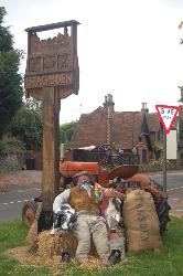
Stagsden village sign September 2007
Name
Stagsden is first recorded, as Stacheden in the Domesday Book of 1086. Other variant spelling through the following years include: Stachdene (1086-1494); Staggeden (1183); Stachesden (1196-1388); Stachenden (1220-1242); Staggesden (1228); Stakeden (1235-1276); Stachedon (1247); Stakesden (1276-1346); Stageden (1276-1526); Stachden (1535); and Stackedene (1553). The first occurrence of the modern spelling was in 1766. The name appears to mean "stake valley", although for many years it was thought to mean "stag valley"; the name presumably refers to a boundary marker of some kind, perhaps that between Bedfordshire and Buckinghamshire as Stagsden is a border parish.
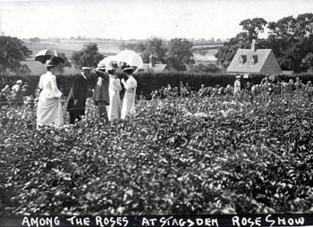
Stagsden Rose Show about 1900 [Z50/107/16]
Administrative History
Stagsden is an ancient parish in the Willey Hundred. The parish lies on the western border of Bedfordshire with Buckinghamshire adjoining the parish of Astwood. It is surrounded on its other sides by: Cranfield (south-west); Kempston Rural (south-east); Bromham (north-east) and Turvey (north-west). The village lies in the eastern part of the parish and was known as Church End; there are also the following hamlets: Bury End (north of the village); North End (north-west of the parish); West End (south of the parish) and Wick End (immediately north-east of the village). East End was transferred to Bromham in 1934.
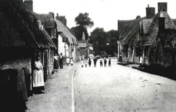
The High Street about 1900 [Z50/107/21]
Population
In 1086 forty five people are listed as attached to the various manors of Stagsden. These were the heads of household so the number needs to be multiplied by a factor of at least four to get an idea of the size of the settlement. This suggests that around 180 people lived in the parish at the time, making it significantly larger than many other Bedfordshire parishes, including a number which are much larger today.
The Hearth Tax of 1671 (transcribed in Bedfordshire Historical Records Society Volume 16 in 1934) records 52 dwellings in Stagsden for a total of 85 hearths. It has been estimated that this represented a population of about 234. The largest number - seven - were in the house of Thomas Gray. No house is noted as containing a forge. The house of Mr.Farrow and one other were empty. Five persons in the parish "receive Collection" dued to poverty.
Volume 81 published by the Bedfordshire Historical Records Society (2002) is devoted to returns made during episcopal visitations to the county by the Bishop of Lincoln in the early 18th century, edited by former County Archivist Patricia Bell. One of the questions asked was the number of nonconformist families in the parish; the various responses were as follows:
- 1706: 73 families, approximately 400 people;
- 1709: 50 families;
- 1717: 70 families;
- 1720: "Three score and four" i.e. 64 families
Unusually, the population of Stagsden rose steadily for the first half of the 19th century then dwindled just as steadily ever since, with a brief resurgence in 1931, though the annexing of East End by Bromham three years later brought the figures down again. The following figures show the trend:
- 1801: 492;
- 1811: 517;
- 1821: 542;
- 1831: 597;
- 1841: 632;
- 1851: 727;
- 1861: 708;
- 1871: 680;
- 1881: 548;
- 1891: 470;
- 1901: 429;
- 1911: 435;
- 1921: 388;
- 1931: 455;
- 1951: 368;
- 1961: 400;
- 1971: 348;
- 1981: 346;
- 1991: 355;
- 2001: 356;
- 2011: 363.