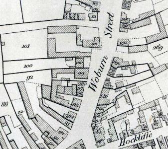
1819 Map of the Southern Part of Woburn Street

Please click on the map above to see a larger image
The map above is part of a larger map published in 1819 by Benjamin Bevan junior [X1/34/1]. In 1821 William Rose of Leighton Buzzard published a reference booklet to accompany the map [X1/34/2]. This booklet gave the owner and occupier of the various buildings and pieces of land on Bevan's map. Below is a transcript of the reference book corresponding to this section of the map, with additions gleaned from Pigot & Company's New Commercial Dictionary for 1823-1824 and other research. Each entry consists of the number, then the name of the owner, then the name of the occupier or occupiers.
Woburn Street
West Side
South to North
- 94: R.Lock; R.Lock [later the Red Lion public house, 1 North Street];
- 95: Nathaniel Stonhill; E.Wright and J.Tebby [site of the later 3 and 5 North Street];
- 96: E.Anthony; E.Anthony [96 to 98 are the site of the later 7, 9, 11 and 13 North Street];
- 97: W.Dumbleton; W.Dumbleton;
- 98: F.Lawley; J.Tring;
- 99: William Chew; William Chew [site of 15 North Street; William Chew was a baker, miller and mealman];
- 100: John How; John How [site of 17 North Street; John How was a corn dealer];
- 101: J.Clark; Self and Miss Walker's [Holly Lodge, later demolished to make way for the modern West Street]
East Side
North to South
- 267: Juliana Franklin; T.Franklin;
- 268: Juliana Franklin; William Heckford [William Heckford was a surgeon;
- 269: T.Chew; T.Chew [later 12 North Street];
- 270: J.Hood; J.Hood [270 and 271 later 10 North Street];
- 271: J.Hood; Joseph Allen;
- 272: T.Dawson; W.Dawson [272 and 273 later 8 North Street];
- 273: T.Dawson; Widow Forth;
- 274: Thomas White; Thomas White [later 6 North Street; Thomas White was a butcher];
- 275: W.White; W.Wyton [later 4 North Street];
- 276: Widow Peppiatt; J.Hide [with 277 site of 2 North Street];
- 277: Widow Peppiatt; J.Charles [J.Charles was a plait dealer]