Cainhoe Castle
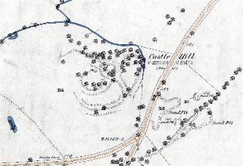
The area around Cainhoe Castle in 1883 - to see a larger version, please click on the image.
Cainhoe Castle remains as a prominent earthwork on the north side of the road from Clophill to Shefford. It was the seat of the Barony of Cainhoe which, under Nigel de Albini owned lands in Husborne Crawley, Tingrith, Harlington, Marston Moretaine, Millbrook, Ampthill, Southill, Maulden, Silsoe, Pulloxhill, Streatley, Milton Ernest, Carlton, Radwell, Turvey, Wyboston, Holme (Biggleswade), Harrowden, Clifton, Henlow and Arlesey as well as Clophill and Cainhoe, with some outlying property in Buckinghamshire, Warwickshire and Leicestershire.
It is possible that the castle was built on the site of Anglo-Saxon settlement. A series of fishponds lies north of the castle and there are earthworks to the west and it seems likely that these earthworks represent the hall described in 1272 when Simon de Albini's possessions were divided between his three sister: "the hall of Kaynho with porch, chamber, cellar towards the east, with bakehouse, dovecote and garden westwards to the ditch of the marsh, the ditch which encloses the court…a ditch extends from the well to the bridge of Baybrugg, thence a ditch near the causeway…to the bottom of the old ditch…fishpond called Walebeck….houses of stone and lime…"
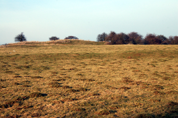
The ground rises towards the baileys March 2010
The castle was of the motte and bailey type. The motte was the mound, on which would have stood a wooden tower. The bailey was the open area enclosed by bank, ditch and wooden wall. In fact, Cainhoe had three separate baileys. The castle was in existence by 1138 when it was captured by the forces of King Stephen on their way to besiege Bedford Castle. The castle itself is last mentioned in the document of 1272 quoted above.
Newsletter 4 of the Council for British Archaeology Group 9 (Bedfordshire, Berkshire, Buckinghamshire, Northamptonshire and Oxfordshire) of 1974 notes (page 14) that trial excavations were carried out for Bedfordshire County Council on a strip of land south of the castle by Alison Taylor and Peter Woodward. The dig was written up in much more detail by the two excavators in charge in Volume 10 of Bedfordshire Archaeological Journal (1975), page 41. The excavation was designed mainly to investigate earthworks outside the castle baileys thought to represent the lost medieval village of Cainhoe. They found a cobbled roadway with drainage ditches leading to a gap in the outer earthworks. Two possible platforms for houses, part of the deserted village, were also found.
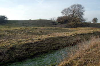
The motte and baileys March 2010
The Historic Environment Record for Bedfordshire [HER] is now on-line as part of the Heritage Gateway website. The entry for Cainhoe Castle [HER 225] reads as follows: "The site lies on the south side of the valley of the River Flitt and comprises a motte and bailey castle, associated moated site with fishponds, and part of a field system. The motte mound utilises a natural sand outcrop, and rises approx 15 metres above the floodplain, it is approximately 60 metres in diameter at the base, with a flat area 10 metres in diameter at the top. To the south, east and west of the motte lie the three irregular-shaped baileys, separated from the motte by a ditch averaging 10 metres wide and 3 metres deep. The western bailey is thought to be the earliest, and its north-western side has been damaged by later quarrying; about two-thirds of its interior survives, measuring 70 metres by 60 metres, and 7 metres below the top of the motte. It is separated from the south bailey by a bank 1 metre high and 10 metres wide, and a ditch 16 metres wide and 3 metres deep. The south bailey is roughly crescent-shaped, approx 120 metres by 40 metres, and 2 metres below the level of the west bailey. On its south side is a bank 8 metres wide, rising 1.5 metres above the interior of the bailey, and on the outer edge sloping down 4 metres to the base of a 20 metre wide ditch. The east bailey measures 80 metres by 30 metres and slopes down from west to east; it is divided from the south by another ditch, 15 metres wide and 5 metres deep, thought to have been part of the castle entrance".
"The castle lies at the eastern end of a large field, 520 metres by 320 metres, which contains earthworks indicating the remains of a medieval manorial site thought to have succeeded the castle. A series of irregular enclosures are marked by field boundary ditches averaging 7 metres wide by 0.5 metre deep; they are truncated to the south and east by a modern road, and to the west by quarrying, and an area of 170 metres by 140 metres in the centre of the field has also been quarried. To the south-west of the field centre is a square enclosure measuring 80 metres across, thought to be a moated site and the location of the manor house. The moat has been partly infilled, but part of the western arm has been adapted as a cattle-pond. The interior of the moat is divided into two by an east-west bank".
"To the north of the site is a series of dried-up fishponds. At least four oval or rectangular ponds are visible, averaging 10 metres wide, and between 22 metres and 34 metres long, and a square pond 20 metres across with a central island".
"Small excavations in 1973 located metalled road surfaces in the vicinity of the castle entrance, and medieval drainage works. The trenches also confirmed that the motte was built on a natural hill".
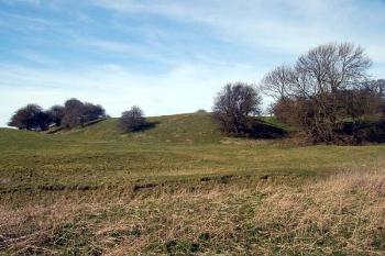
Cainhoe Castle March 2007