The Community of Leighton Buzzard in General
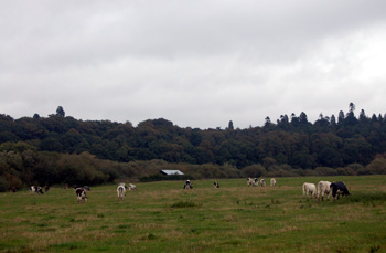
The Heath seen from Old Linslade Road October 2008
Landscape
Before the modern civil parishes of Billington, Eggington, Heath & Reach and Stanbridge were split off the ancient parish of Leighton Buzzard was a colossal 10,558 acres [4,273 hectares]. Before its amalgamation with Linslade in 1965 the reduced parish of Leighton Buzzard comprised 2,441 acres [988 hectares]. The modern civil parish of Leighton-Linslade contains 4,134 acres [1,673 acres].
Leighton Buzzard forms the eastern half of the drainage basin feeding the southern end of the River Ouzel. Near the river there are deposits of alluvium and, more importantly for the industrial history of the town, areas of gravel which have been commercially excavated. Still more important are the areas of the Greensand suitable for commercial quarrying. Leighton Buzzard, like Heath and Reach, is dotted with old sand quarries including those still visible in the modern landscape:
- a large quarry in the extreme south-east, which is also in the parish of Billington;
- a quarry between the Grovebury Road Industrial Estate and the River Ouzel;
- a quarry to the east of Billington Road, again partly in the civil parish of Billington and now [2008] being developed as a housing estate;
- Deadman's Slade between Plantation Road and Heath Road in the area of Adam's Bottom;
- Chamberlain's Barn east of Heath Road and south of Broomhills Farm.
The sand comes, as noted above, from alluvium but further from the river is a band of sand and gravel known as river terrace deposit. Most of the solid geology in Leighton Buzzard is a type of greensand sandstone known as Woburn Sands Formation, laid down in shallow Cretaceous seas between 99 and 121 million years ago. To the south-east of the town, between Pages Park and the A4012 is an area of mudstone known as Oxford Clay Formation which was laid down in the Jurassic Period between 154 and 164 million years ago.
The land varies from a low point of 245 feet above sea level in the flooded gravel pit between the Grand Union Canal and the A505 to 415 feet at the telecommunications mast on Shelney Hill in the north of the parish. Other spot heights include the church at 300 feet, the market cross at 307 feet above sea-level, the White House at 316 feet, the Falcon public house at 280 feet, the site of the former water tower at 320 feet above sea-level, Adam's Bottom at 290 feet and Heath Court at 375 feet above sea-level
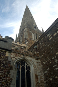
All Saints spire June 2008
Name
According to Bedfordshire Place Names by A.Mawer and F.M.Stenton, the name Leighton means a kitchen garden from the Old English word "leactun". The Oxford Dictionary of English Place Names is s little more specific, describing the word as meaning "the place where leeks are grown".
The Buzzard element first appears as Busard in a Lincoln deed of 1242. At the Bedford Eyre of 1247 John de Sancto Egidio, then Vicar of Leighton Buzzard said that: "one Theobald de Busar, formerly his predecessor as parson of the said church in the time of King Richard…and he himself…were in possession of services". A Theobald de Bosat, likely the same man as Theobald de Busar, was witness to a charter of the Dean of Lincoln at some time between 1189 and 1195.
The last name of this Theobald seems to have been added to the name Leighton; it may be that around this time there was confusion in the Diocese of Lincoln between two prebendaries and parishes called Leighton, one from Bedfordshire the other from Huntingdonshire and so the names of their respective prebends were added to distinguish them - giving us today both Leighton Buzzard and Leighton Bromswold.
Various forms of Leighton include: Lestone (1086); Lehtone (1164-1240); Lechtone (1173-1202); Leocton (1177); Lectune (1194); Lecton (1195-1253); Leiton or Leyton (1206-1227); Legthon (1247-1287) and Lachton (1264). Various forms of Buzzard include: Bussard (1287-1656); Busard (1287-1477); Bousard (1331); Bosard (1355-1499); Bussarde (16th century); Beaudesert (1643); Beudesert (1646); Budezard (1646); Buzard (1649) and Beuzard (1655).
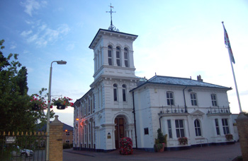
The White House June 2008
Administrative History
Leighton Buzzard is an ancient parish in the Manshead Hundred. Historically it also included the hamlets of Billington, Eggington, Heath & Reach and Stanbridge. These hamlets all became separate civil parishes in 1866 having become separate ecclesiastical parishes at various dates - Stanbridge in 1735, Eggington in 1810, Billington and Heath & Reach both in 1826.
Thus for a century from 1866 to 1965 Leighton Buzzard was a civil and ecclesiastical parish which, between 1891 and 1965 was also an Urban District, having its own dedicated Urban District Council as a second tier authority under the County Council.
In 1965 the ancient Buckinghamshire parish of Linslade was transferred into Bedfordshire and amalgamated with Leighton Buzzard to form a new civil parish, and Urban District, of Leighton-Linslade. The ecclesiastical parishes remained separate. The Urban District was abolished in 1974 and Leighton-Linslade became part of the newly formed South Bedfordshire District Council (which lasted until 2009 when the amalgamated with Mid Bedfordshire District Council and elements of the abolished Bedfordshire County Council to form a new unitary authority called Central Bedfordshire). Thus Leighton Buzzard is a very large hamlet or township in the civil parish of Leighton-Linslade!
Leighton Buzzard is bordered by Linslade to the west, Heath & Reach to the north, Eggington to the east, Billington to the east and south-east, Slapton [Buckinghamshire] to the south and Grove [Buckinghamshire] to the south-west. Leighton-Linslade has similar boundaries with the addition of Wing [Buckinghamshire] to the south-west and Soulbury [Buckinghamshire] to the west.
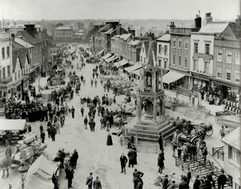
The Market Square and High Street on market day about 1900 [Z50/72/109]
Population
The Hearth Tax of 1671 (transcribed in Bedfordshire Historical Records Society Volume 16 in 1934) records 270 dwellings in Leighton Buzzard for a total of 603 hearths. It has been estimated that this represented a population of about 1,113. The largest number - sixteen - was in the house of Francis Winton. The houses of John Ashwell, Thomas Can, Robert Capon and William Stayre each contained a forge, clearly suggesting they were smiths. Eight almshouses were recorded
The occasional visitation by the Bishop of Lincoln to Bedfordshire in the early 18th century gives important social information. Each vicar or rector had to complete a return about his parish. These are particularly useful for the state of education but give other insights. Former County Archivist Patricia Bell has compiled returns from 1706 to 1720 for the Bedfordshire Historical Records Society (Volume 81, published 2002); information for Leighton Buzzard includes the following:
- 1706: "In Leighton 309 families, Souls 1220";
- 1717: "About 330 familys" [sic];
- 1720: "We have nearly four hundred families in the Town of Leighton"
The population of the town of Leighton Buzzard can be traced from census returns; figures from 1971 are for the combined parish of Leighton-Linslade.
- 1801: 1,963;
- 1811: 2,114;
- 1821: 2,749;
- 1831: 3,330;
- 1841: 3,965;
- 1851: 4,465;
- 1861: 4,330;
- 1871: 5,361;
- 1881: 5,991;
- 1891: 6,704;
- 1901: 6,331;
- 1911: 6,782;
- 1921: 6,797;
- 1931: 7,030;
- 1951: 9,025;
- 1961: 11,745;
- 1971: 20,347;
- 1981: 29,868;
- 1991: 31,889;
- 2001: 32,415;
- 2011: 37,469.
Leighton-Linslade was, as of 2001, the fourth largest community in terms of population in the county, behind Luton (184,371) Bedford (77,885) and Dunstable (33,805) but in 2011 it overtook Dunstable (36,253) to reach the number three spot.