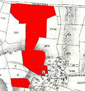
Green Hill Farm in 1804 (note that the top of the map is north-east, not north)
Virtually all of Tilsworth was owned by Tilsworth Manor until well into the 19th century. In the Tilsworth Estate sale particulars of 1804 [AD534/4], Green Hill Farm was tenanted by people called Perrott and comprised the farmhouse and a total of 121 acres 3 roods 19 perches of land. The farmhouse is described thus: "A Substantial Brick and Tiled FARM HOUSE, containing a Parlour, Kitchen, back Kitchen, Dairy, Five Bed Chambers, Three Barns, containing Nine Bays, Wood House, Cow House, two Stables, Waggon Lodge, Straw Hovel and Pig Sty (Timber Weather Boarded and Thatched) Yard and Croft".
The land comprised:
- Roads Crouch; 24 acres 7 perches;
- Rick Meadow; 23 acres 38 perches;
- Hales Hole; 28 acres 1 rood 30 perches;
- Green Hill; 26 acres 1 rood 35 perches;
- Eleven Leys; 3 acres 25 perches;
- Deans; 4 acres 2 roods 9 perches;
- Deans; 4 acres 3 roods 22 perches;
- Homeleys; 1 acre 1 rood 29 perches;
- a croft and rough land; 1 acre 3 roods 1 perch;
- rough land; 1 acre 3 roods;
- a farmhouse; 1 acre 30 perches;
Green Hill Farm was evidently sold by the Tilsworth Manor estate as in 1916 it was sold by the executors of Samuel Yirrell [BML10/72/5]. At that date the farm comprised the farmhouse, homestead and 116 acres 1 rood 26 perches of land, very similar in size to 1804. The discrepancy was caused by the fact that the farm no longer contained the nine acres or so contained by the two fields called Deans and numbered 15 and 16 on the 1804 sale map. Instead it contained part of the field called The Hides and marked XVII on the 1804 map, to make a straight line down the south-eastern boundary of fields XV and XVI (Hales Hole and Green Hill). The farmhouse was described as comprising an entrance hall, dining room, kitchen, dairy and scullery on the ground floor with four "roomy" bedrooms, a landing and bathroom with W.C. above. The homestead comprised timber and thatch stabling, two barns, an open hovel, a large shed with an iron roof, a timber and thatched shed and loose box, and a four bay shed opening onto a field. The land was largely grazing but Rick Meadow (XIV on the 1804 map) was arable. The farm was occupied by Charles Wood who paid £244/9/- per annum rent. The farm was bought for £4,500 by J.R.Labrum.
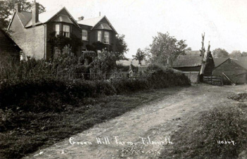
Green Hill Farm about 1920 [Z1304/124]
The Rating and Valuation Act 1925 ordered every piece of land and building in the country to be assessed to determine the rates to be paid on it. The valuer visiting Green Hill Farm [DV1/H28/54] noted that it was owned and occupied by Charles Wood, the former tenant, who had bought the place in 1921 for £4,040. The farm contained 116½ acres. The valuer commented that the larger part of homestead had burnt down on 24th August 1926. He commented: "Large house".
The large house was built of brick and slate and comprised two reception rooms, a kitchen, scullery and dairy downstairs with four bedrooms and a bathroom above. A weather boarded and thatched coal barn stood outside. Not surprisingly, only seven months after the fire, the homestead was somewhat abbreviated, containing just two weather boarded and corrugated iron piggeries, a weather boarded and thatched feeding hovel, a brick, weather boarded and corrugated iron for bay open hovel, a weather boarded and corrugated iron four bay open hovel and a two bay open cart shed.
The farm was again sold in 1938, by Charles Wood [BML10/72/6]. A few more details of the house are given: both the dining and drawing room had a large bay window and was fitted with a tiled grate and hearth; the kitchen had a grate and the scullery a copper, sink and grate. The homestead now comprised a new four bay Dutch barn with timber extension, a range of timber and iron roofed buildings comprising a cart shed, piggery and meal house and a similarly built four bay structure containing a hovel, cow house, stable, open hovel, loose boxes and barn. The land was almost identical to that in 1916, the only difference being that Roads Crouch (XIII on the 1804 map) now contained 23 acres 2 roods 8 perches instead of the 23 acres 2 roods 34 perches of 1916). The farm was sold for £5,000.