The Parish of Aspley Heath in General
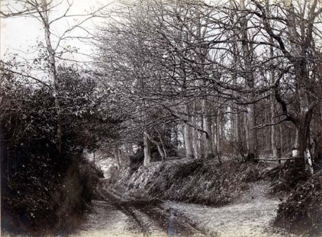
This photograph was taken by a member of the Newman family around 1900 and is captioned "Sandy Lane end of Narrow Path"
[Ref. Z251/303/8]
Landscape
The Heath had been seen since the 18th century as a particularly healthy spot, mainly because it saw a smaller fluctuation between winter cold and summer heat than almost anywhere else in the country. The Heath owes its rather Swiss air to Francis Moore of Aspley Guise, who purchased 500 acres of Wavendon Heath for a few hundred pounds and planted the very precise figure of 51,376 Scotch firs, for which he received a gold medal from the Society for the Encouragement of Art and Manufactures. Moore subsequently sold the 500 acres to the Duke of Bedford, in 1792, for £17,116.
Before this the Heath, or Wavendon Heath as it was then called, would have been open sandy moorland, used for grazing. John Trimmer has carried out considerable research on Welsh cattle drovers. He has provided information to Bedfordshire and Luton Archives and Records Service that that heath would have been crossed by these Welsh drovers from the Middle Ages onwards, the final part of their route extending from Stratford-upon-Avon [Warwickshire] to London and Essex.
The Heath is quite high - the church stands at just over 400 feet above sea level. The Knoll stands at around 545 feet. the lowest point, on Hardwick Road averages 360 feet above sea level.
John Trimmer writes that In the 18th Century there were a number of outbreaks of cattle plague in England, which restricted the movement of cattle and closed markets and fairs. The main outbreak lasted some ten years, and in 1748 drovers and cattle men organised their own sales on Wavendon Heath to avoid checks and certification, according to John Broad in his article on
Cattle Plague in Eighteen Century England published in 1983. They would have needed the watering-holes of Mermaid's Pond in Aspley Guise and the ponds near
Longslade Cottage which appear to have been man- made, to have made the unofficial fair possible. The Welsh would have made use of these ponds when crossing the Greensand Ridge. There was a Welsh settlement of London End at Bow Brickhill and at
Woburn, created in the Medieval period.
The solid geology of Aspley Heath is sandstone knowm, appropriately, as Woburn Sands Formation. It was formed between 99 and 121 million years ago during the Cretaceous Period in an environment of warm, shallow seas. In the west of the parish is an area of Woburn Sands Formation which is known as Smectite-Claystone and is synonymous with Fuller's Earth. The superficial geology is, as one would expect, sandy soil, though of no great depth. The first known reference to Fuller's earth in the area is in a conveyance of 1668 [HC50], though the deposits in this parish are now more or less exhausted, Aspley Guise being the current [2011] focus for mining.
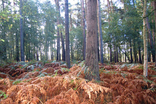
Aspley Heath Woods September 2007
Name
The name Aspley (taken from Aspley Guise, from which the parish was created) was first recorded in the charter setting out the boundaries in 969 as Aepslea, by which it was known as late as 1229. Other variants of the name include Aspeleia (1086 - the Domesday Book), Aspele or Asplelegh (1202 and later) and Aspeleye Gyse (1363). The word Aspley is Old English for "aspen-tree clearing".
Administrative History
Aspley Heath is a modern creation. The parish was previously part of Aspley Guise and was created as a separate civil parish in 1883. Confusingly although the church is in Aspley Heath the ecclesiastical parish (created in 1867) is called Woburn Sands and covers both civil parishes (despite the fact they are in separate counties, Aspley Heath in Bedfordshire and Woburn Sands in Buckinghamshire). In 1886 parts of Wavendon were also transferred to Aspley Heath to make a parish of about 600 acres.
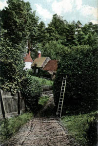
Leighton Hollow about 1900 [Z143/5]
Population
Before the nineteenth century The Heath was largely woodland with very few settlements; at the inclosure of Aspley Guise in 1761 the Commissioners reserved The Heath as a common sheep pasture but people soon began to move onto it more or less as squatters. The Topography and Climate of Aspley Guise noted in 1858 that the Heath had been annexed by a colony of independent settlers, who had "erected tenements of some little value".
At an early date the only road acros The Heath was Leighton Hollow, today's Sandy Lane. The road up to the newly built church was metalled in the late 19th century and some larger, grander houses began to appear. The last of the old dwellings were in Leighton Hollow in a place called George's Square. There was little industry in the parish, save for a rope walk at what is now the Garden House and the early extraction of fuller's earth.
The population of Aspley Heath has always been quite stable as the following figures show:
- 1891: 451
- 1901: 462
- 1911: 572
- 1921: 522
- 1931: 499
- 1951: 460
- 1961: 490
- 1971: 579
- 1981: 536
- 1991: 507
- 2001: 574
- 2011: 578