Maps and Land Records
The Archives Service map collection is one of the most important and frequently used sources in our entire holdings. Even if you have not used the collection yourself, you may have been intrigued to see other readers doing so, and begun to wonder about the types of maps available and their research potential. Many of our maps are large and imposing - some are up to ten feet square - and they also bring home the fact that our searchroom is too small by today's standards!
Maps are used by our whole range of researchers – from the family historian attempting to find out where an ancestor lived or the local historian tracing the growth and development of a particular place – to a specialist firm tracing the history of a contaminated piece of land or the legal researcher interested in a particular right of way. There are two books in our library (both at class: 0) that provide useful introductions to the topic; Maps and Plans for the Local Historian and Collector by David Smith, and Maps for Family History by William Foot (Public Record Office Readers' Guide No. 9). In this article I shall describe the finding aids for the map collection and look briefly at the types of maps available.
Maps can be divided into two broad categories, printed maps and those in manuscript form. The first category includes maps of Bedfordshire produced from the late 16th century by commercial publishers and the Ordnance Survey (0.S) series produced from c.1800. Other types of printed maps, notably those in auction sale catalogues (see card index under: AUCTION SALES & LAND: sale catalogues <place> became more common in the 19th century, later using existing O.S. maps as a base to which additional data such as lot numbers could be added. The same can also be said for the various fire insurance maps we hold produced by the firm Charles Goad. We have an excellent set for the central portion of Luton for 1895, revised to 1958 (Ref: Z 561) and others for the towns of Bedford, Biggleswade, Dunstable, Leighton Buzzard and Luton, published in the early 1970s (Ref: Z 507/15-22). Incidentally, we have a useful guide to British Fire Insurance Plans by Gwyn Rowley (pamphlet class: 60).
Sometimes, maps combine the qualities of the printed map with those of their manuscript cousins. For example, the printed 25-inch scale O.S. maps of 1901 (2nd edition) and 1924-6 (3rd edition) were respectively used as base maps for the Inland Revenue Domesday Survey of 1910 and the local Valuation Rating Act survey of 1925.We have an almost complete set of these surveys for the entire County. The maps were colour washed and annotated with reference numbers which tie in with the survey books. The books for 1910 record owners and occupiers of property and provide some financial data, while those for 1925 often provide extra details, including brief descriptions of buildings and their state of repair. The catalogue of these surveys, together with detailed notes on their research potential, is in our searchroom (brown catalogue: DBV:DV).
There are several indexes to the map collection in the searchroom. One of the most important is the card index arranged alphabetically by parish, currently in one of the index drawers in the corner of the searchroom. It is important to realise that this parish index does not cover O.S. maps or other printed maps in series covering a large portion of the County. The green header card(s) at the front of each parish index simply lists the reference numbers and the gives the date of each item. No other data is given, but the card helps the searcher determine the number of maps for each place and the date range. Moreover, a blue asterisk on the card indicates that a reduced size photograph of the map is in the map tank in the opposite corner of the searchroom. The individual map cards which follow are arranged chronologically and describe the maps in some detail, giving the title, surveyor, scale and whether the map includes the whole parish or just a few fields belonging to a particular estate.
It is rare to find a map much older than 1750. The three oldest examples are estate maps dating from the late 16th century and cover the Warren, Little Park and Houghton Park, Ampthill, c.1580 (Ref: X 1/77), Toddington, 1581 (Ref:X 1/102) and the estates of All Souls' College, Oxford, at Holcote, Salford and Ridgmont in 1595-96 (Ref: X 1/74). All these maps are copies of originals held elsewhere: the earliest original map we hold is for the Manor of Bushmead, Eaton Socon in 1624 (Ref: GY 4/1-2).
The other two main types of map included in this index are those for the Parliamentary Inclosures, generally from 1760 to 1820 and surviving for most parishes, and Tithe apportionments, usually c.1840. The background to the compilation of these maps and their accompanying schedules and papers is too complex to be covered here.
Enclosure and Tithe maps are especially valuable in that they often cover the major part of a parish, while the schedules frequently contain names of owners and occupiers of property, as well as other information. Both types of map have their own special catalogues in the searchroom, describing the map and accompanying records for each parish in detail (see brown spring-back binders on the catalogue shelves).
There are other indexes in the parish map drawer: a listing of out-of-county maps, an alphabetical index of surveyors derived from our entire map holdings, and a chronological index of printed County maps from 1576. The latter is covered in detail in Printed Town Maps and Town Plans of Bedfordshire by Betty Chambers (Bedfordshire Historical Record Society Vol. 62, 1983: book class 110). We now turn to one of the most important types of maps – the Ordnance Survey series. The general guide to these maps is on the catalogue shelves (green spring-back binder: Map Catalogue: Ordnance Survey ). The contents page gives a summary of the scales available from the smallest, the half inch to the mile series, to the largest (1:500 series). Some of these maps can be ordered from the stacks using the grid keys in the catalogue, but the most frequently used 6' scale maps of c.1880 (1st edition), 1902 (2nd edition) and c.1960 are stored in the searchroom. Nearby is the key sheet to the 25" scale maps which are available for much of the County.
The 1:500 scale O.S. maps of 1878-1884 are worthy of special mention [ref: MC1]. These maps were prepared for the central parts of Bedford, Biggleswade, Dunstable, Leighton Buzzard and Luton, and to such a level of detail that even the location of lamp posts and post boxes are indicated as well as the names of individual villas. Richard Oliver's book Ordnance Survey Maps: a concise guide for historians is essential background reading on these and other maps in the O.S. series (book 0).
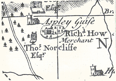
Aspley Guise, from Gordon's printed map of Bedfordshire, 1736 (Ref: Z50/143/183)
Alongside the guide to the O.S. maps is a similar listing of other printed maps in our collections. These include printed County maps and maps deposited with the local authority as a statutory requirement for the proposed construction of canals and waterways (Ref: MCW series) and highways (Ref: M Hi.d), main roads (Ref: MMR) and turnpike trust roads (Ref: MTR). Similar deposited maps for proposed railway routes affecting the County dating from the 1840s are listed in yet another catalogue (Ref: PDR series).
We cannot leave this brief survey of the map collection without mentioning two things which affect the way we are able to use it: copying and copyright. Many of the maps are bulky and extremely fragile so it may not always be possible to take photocopies. Sometimes we can make copies from existing photographs, but often the only option is studio photography. We are hoping to acquire a digital camera soon which should make it easier to photograph portions of maps.
It is usually possible to photocopy the printed O.S. maps freely, but only providing that they are over 70 years old (recently increased from 50 years by an E.C. law). For maps under 70 years old, we can only provide 100 square inches from any one sheet (approximating to a single A4-sized copy), and then only under a fair-dealing clause limiting their use to private study or research. If larger areas of the maps are required, or if any copies are needed for business reasons, you are required to have a licence or obtain permission from the O.S.
Ordnance Survey Maps