Hatch Maps
The following maps are only a selection of those held at Bedfordshire Archives. The map below shows Hatch on the Northill inclosure map of 1783 [ref: MA2]. To see a larger version please click on the image.
![Brook End and Hatch in 1783 [MA2]](/CommunityHistories/Hatch/HatchImages/Brook End and Hatch in 1783 [MA2]_291x300.jpg)
Brook End and Hatch in 1783 [ref: MA2]
The two maps below are taken from Ordnance Survey 25 inches to the mile sheets, specifically the 1st edition of 1883 and the second edition of 1901. To see a larger version, please click on the relevant image.
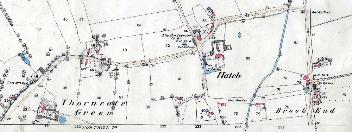
Brook End, Hatch and Thorncote in 1883
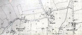
Brook End, Hatch and Thorncote in 1901