Beadlow Maps
The following maps are only a selection of those held at Bedfordshire Archives. These maps of Beadlow are: the inclosure map of 1826 [ref: MA55]; a larger sheet of the Ordnance Survey 1st edition map of the area dated 1883 and an Ordnance Survey 6 inches to the mile map annotated by the first County Archivist, Doctor Fowler, to show the known field names in Beadlow respectively. To see a larger version, please click on the image.
![Beadlow on the Clophill inclosure map of 1826 [MA55]](/CommunityHistories/Beadlow/BeadlowImages/Beadlow on the Clophill inclosure map of 1826 [MA5_349x275.jpg)
Beadlow on the Clophill inclosure map of 1826 [ref: MA55]
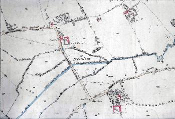
Beadlow in 1883
![Field names in Beadlow [MC1-3-3-11]](/CommunityHistories/Beadlow/BeadlowImages/Field names in Beadlow [MC1-3-3-11]_350x294.jpg)
Field names in Beadlow [ref: MC1/3/3/11]